El Chico geodata
El Chico (Veracruz) is a populated place; located in Mexico in America/Mexico_City (GMT-6) time zone. With population of 2,480 people, there are 3566 cities with bigger population in this country. Compared to other cities in Mexico, 54.8% of cities are located further ↑North; 76.8% of cities are located further ←West and 59.2% of cities have higher elevation than El Chico. Note1


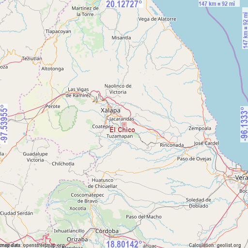
El Chico GPS coordinates[2]
19° 27' 56.52" North, 96° 50' 11.112" West
| Map corner | latitude | longitude |
|---|---|---|
| Upper-left | 20.12727°, | -97.53955° |
| Center: | 19.4657°, | -96.83642° |
| Lower-right: | 18.80142°, | -96.1333° |
| Map W x H: | 147.4×147.4 km | = 91.6×91.6mi |
| max Lat: | 32.7° ⇑54.8% North |
| El Chico: | 19.4657° |
| min Lat: | ⇓45.2% South 14.53588° |
| min Long | El Chico | max Long |
| -117.105° | -96.83642° | -86.73105° |
| W 76.8%⇐ | ⇒23.2% E |
Elevation
Elevation of El Chico is 1041 m = 3415 ft, and this is 212.7 m = 698 ft below average elevation for this country.
| Max E: |
3497 m = 11473 ft | 59.2% |
| Avg. | 1253.7 m = 4113 ft | |
| El Chico | 1041 m = 3415 ft | |
Min E: |
-1 m = -3 ft | 40.8% |
See also: Mexico elevation on elevation.city.
Geographical zone
El Chico is located in North Torrid zone (between Equator and Tropic of Cancer). Distance of this Northern Tropic circle is 441.5 km =274.3 mi to North.| Distance of | km | miles | from El Chico |
|---|---|---|---|
| North Pole | 7842.7 | 4873.2 | to North |
| Arctic Circle | 5236.8 | 3254 | to North |
| Tropic Cancer | 441.5 | 274.3 | to North |
| Equator | 2164.4 | 1344.9 | to South |


Nearby cities:
15 places around El Chico: (largest is in red/bold)
• Alborada
4.1 km =2.5 mi,  242°
242°
• Bella Esperanza
4.8 km =3 mi,  221°
221°
• Chavarrillo
6.3 km =3.9 mi,  135°
135°
• Colonia Santa Bárbara
5.9 km =3.7 mi,  312°
312°
• Colonia la Perseverancia
4.7 km =2.9 mi, 313°
• Dos Ríos
4.4 km =2.7 mi,  62°
62°
• El Lencero
3.3 km =2.1 mi,  39°
39°
• Estación Chavarrillo
5 km =3.1 mi,  145°
145°
• Estanzuela
2.3 km =1.4 mi,  256°
256°
• Fraccionamiento las Fuentes
6.2 km =3.9 mi,  302°
302°
• Jacarandas
3.7 km =2.3 mi,  332°
332°
• Las Trancas
5.2 km =3.2 mi, 325°
• Lomas de Miradores
5.3 km =3.3 mi,  97°
97°
• Pacho Nuevo
4.6 km =2.9 mi,  286°
286°
• Rancho Viejo
6.2 km =3.9 mi,  112°
112°
Sources, notices
• [Note1] Compared only with cities in Mexico existing in our database
• [Src1] Map data: © OpenStreetMap contributors (CC-BY-SA)
• [Src2] Other city data from geonames.org with taken over terms of usage.
• [Src3] Geographical zone / Annual Mean Temperature by Robert A. Rohde @ Wikipedia
