El Lencero geodata
El Lencero (Veracruz) is a populated place; located in Mexico in America/Mexico_City (GMT-6) time zone. With population of 1,887 people, there are 4609 cities with bigger population in this country. Compared to other cities in Mexico, 54.3% of cities are located further ↑North; 77.1% of cities are located further ←West and 59.7% of cities have higher elevation than El Lencero. Note1


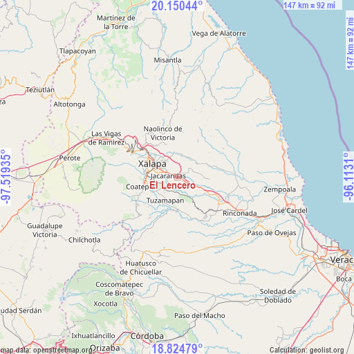
El Lencero GPS coordinates[2]
19° 29' 20.292" North, 96° 48' 58.392" West
| Map corner | latitude | longitude |
|---|---|---|
| Upper-left | 20.15044°, | -97.51935° |
| Center: | 19.48897°, | -96.81622° |
| Lower-right: | 18.82479°, | -96.1131° |
| Map W x H: | 147.4×147.4 km | = 91.6×91.6mi |
| max Lat: | 32.7° ⇑54.3% North |
| El Lencero: | 19.48897° |
| min Lat: | ⇓45.7% South 14.53588° |
| min Long | El Lencero | max Long |
| -117.105° | -96.81622° | -86.73105° |
| W 77.1%⇐ | ⇒22.9% E |
Elevation
Elevation of El Lencero is 1017 m = 3337 ft, and this is 236.7 m = 777 ft below average elevation for this country.
| Max E: |
3497 m = 11473 ft | 59.7% |
| Avg. | 1253.7 m = 4113 ft | |
| El Lencero | 1017 m = 3337 ft | |
Min E: |
-1 m = -3 ft | 40.3% |
See also: Mexico elevation on elevation.city.
Geographical zone
El Lencero is located in North Torrid zone (between Equator and Tropic of Cancer). Distance of this Northern Tropic circle is 438.9 km =272.7 mi to North.| Distance of | km | miles | from El Lencero |
|---|---|---|---|
| North Pole | 7840.1 | 4871.6 | to North |
| Arctic Circle | 5234.2 | 3252.4 | to North |
| Tropic Cancer | 438.9 | 272.7 | to North |
| Equator | 2167 | 1346.5 | to South |


Nearby cities:
15 places around El Lencero: (largest is in red/bold)
• Alborada
7.3 km =4.5 mi,  231°
231°
• Chavarrillo
7.4 km =4.6 mi,  162°
162°
• Colonia Santa Bárbara
6.7 km =4.2 mi,  282°
282°
• Colonia la Perseverancia
5.5 km =3.4 mi, 276°
• Dos Ríos
1.8 km =1.1 mi,  106°
106°
• El Chico
3.3 km =2.1 mi,  219°
219°
• El Terrero
5.6 km =3.5 mi,  18°
18°
• Estación Chavarrillo
6.8 km =4.2 mi,  173°
173°
• Estanzuela
5.4 km =3.4 mi, 234°
• Jacarandas
3.9 km =2.4 mi, 280°
• La Tinaja
7 km =4.3 mi,  64°
64°
• Las Trancas
5.3 km =3.3 mi,  288°
288°
• Lomas de Miradores
4.5 km =2.8 mi,  135°
135°
• Pacho Nuevo
6.7 km =4.2 mi,  258°
258°
• Rancho Viejo
6.1 km =3.8 mi, 143°
Sources, notices
• [Note1] Compared only with cities in Mexico existing in our database
• [Src1] Map data: © OpenStreetMap contributors (CC-BY-SA)
• [Src2] Other city data from geonames.org with taken over terms of usage.
• [Src3] Geographical zone / Annual Mean Temperature by Robert A. Rohde @ Wikipedia
