Estanzuela geodata
Estanzuela (Veracruz) is a populated place; located in Mexico in America/Mexico_City (GMT-6) time zone. With population of 4,492 people, there are 2050 cities with bigger population in this country. Compared to other cities in Mexico, 54.9% of cities are located further ↑North; 76.6% of cities are located further ←West and 59.3% of cities have higher elevation than Estanzuela. Note1


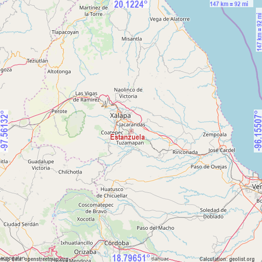
Estanzuela GPS coordinates[2]
19° 27' 38.916" North, 96° 51' 29.484" West
| Map corner | latitude | longitude |
|---|---|---|
| Upper-left | 20.1224°, | -97.56132° |
| Center: | 19.46081°, | -96.85819° |
| Lower-right: | 18.79651°, | -96.15507° |
| Map W x H: | 147.4×147.4 km | = 91.6×91.6mi |
| max Lat: | 32.7° ⇑54.9% North |
| Estanzuela: | 19.46081° |
| min Lat: | ⇓45.1% South 14.53588° |
| min Long | Estanzuela | max Long |
| -117.105° | -96.85819° | -86.73105° |
| W 76.6%⇐ | ⇒23.4% E |
Elevation
Elevation of Estanzuela is 1033 m = 3389 ft, and this is 220.7 m = 724 ft below average elevation for this country.
| Max E: |
3497 m = 11473 ft | 59.3% |
| Avg. | 1253.7 m = 4113 ft | |
| Estanzuela | 1033 m = 3389 ft | |
Min E: |
-1 m = -3 ft | 40.7% |
See also: Mexico elevation on elevation.city.
Geographical zone
Estanzuela is located in North Torrid zone (between Equator and Tropic of Cancer). Distance of this Northern Tropic circle is 442.1 km =274.7 mi to North.| Distance of | km | miles | from Estanzuela |
|---|---|---|---|
| North Pole | 7843.2 | 4873.5 | to North |
| Arctic Circle | 5237.3 | 3254.3 | to North |
| Tropic Cancer | 442.1 | 274.7 | to North |
| Equator | 2163.8 | 1344.5 | to South |


Nearby cities:
15 places around Estanzuela: (largest is in red/bold)
• Alborada
1.9 km =1.2 mi,  224°
224°
• Bella Esperanza
3.2 km =2 mi,  195°
195°
• Colonia Santa Bárbara
5 km =3.1 mi,  335°
335°
• Colonia la Perseverancia
4 km =2.5 mi, 343°
• El Chico
2.3 km =1.4 mi,  76°
76°
• El Lencero
5.4 km =3.4 mi,  54°
54°
• Estación Chavarrillo
6.3 km =3.9 mi,  125°
125°
• Fraccionamiento las Fuentes
4.9 km =3 mi,  323°
323°
• Jacarandas
3.9 km =2.4 mi,  8°
8°
• Las Lomas
5.2 km =3.2 mi,  253°
253°
• Las Trancas
4.9 km =3 mi,  352°
352°
• Lomas Verdes
5.8 km =3.6 mi,  326°
326°
• Pacho Nuevo
2.8 km =1.7 mi,  310°
310°
• Pacho Viejo
6.6 km =4.1 mi,  291°
291°
• Tuzamapan
6.5 km =4 mi,  185°
185°
Sources, notices
• [Note1] Compared only with cities in Mexico existing in our database
• [Src1] Map data: © OpenStreetMap contributors (CC-BY-SA)
• [Src2] Other city data from geonames.org with taken over terms of usage.
• [Src3] Geographical zone / Annual Mean Temperature by Robert A. Rohde @ Wikipedia
