Cutzaro geodata
Cutzaro (Michoacán) is a populated place; located in Mexico in America/Mexico_City (GMT-6) time zone. With population of 664 people, there are 13077 cities with bigger population in this country. Compared to other cities in Mexico, 55.1% of cities are located further ↑North; 75.9% of cities are located further →East and 84.1% of cities have lower elevation than Cutzaro. Note1


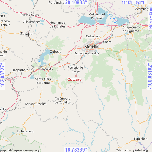
Cutzaro GPS coordinates[2]
19° 26' 51.864" North, 101° 20' 2.904" West
| Map corner | latitude | longitude |
|---|---|---|
| Upper-left | 20.10938°, | -102.03727° |
| Center: | 19.44774°, | -101.33414° |
| Lower-right: | 18.78339°, | -100.63102° |
| Map W x H: | 147.4×147.4 km | = 91.6×91.6mi |
| max Lat: | 32.7° ⇑55.1% North |
| Cutzaro: | 19.44774° |
| min Lat: | ⇓44.9% South 14.53588° |
| min Long | Cutzaro | max Long |
| -117.105° | -101.33414° | -86.73105° |
| W 24.1%⇐ | ⇒75.9% E |
Elevation
Elevation of Cutzaro is 2244 m = 7362 ft, and this is 990.3 m = 3249 ft above average elevation for this country.
| Max E: |
3497 m = 11473 ft | 15.9% |
| Cutzaro | 2244 m 7362 ft | |
| Avg. | 1253.7 m = 4113 ft | |
Min E: |
-1 m = -3 ft | 84.1% |
See also: Mexico elevation on elevation.city.
Geographical zone
Cutzaro is located in North Torrid zone (between Equator and Tropic of Cancer). Distance of this Northern Tropic circle is 443.5 km =275.6 mi to North.| Distance of | km | miles | from Cutzaro |
|---|---|---|---|
| North Pole | 7844.7 | 4874.5 | to North |
| Arctic Circle | 5238.8 | 3255.2 | to North |
| Tropic Cancer | 443.5 | 275.6 | to North |
| Equator | 2162.4 | 1343.7 | to South |


Nearby cities:
15 places around Cutzaro: (largest is in red/bold)
• Acuítzio del Canje
5.4 km =3.4 mi,  1°
1°
• Chihuerio
7.5 km =4.7 mi,  302°
302°
• El Pedregal
14 km =8.7 mi, 300°
• El Sobrado
15.4 km =9.6 mi, 298°
• Etúcuaro
12.8 km =8 mi,  104°
104°
• Huiramba
15.3 km =9.5 mi,  315°
315°
• Lagunillas
15.4 km =9.6 mi,  326°
326°
• Las Tablas
12.7 km =7.9 mi, 297°
• San Andrés Coapa
7.6 km =4.7 mi, 317°
• San José Coapa
13.4 km =8.3 mi,  336°
336°
• San Rafael Coapa
9.2 km =5.7 mi, 341°
• Tirio
14 km =8.7 mi,  24°
24°
• Tirípetio
11.3 km =7 mi,  353°
353°
• Villa Madero
8.5 km =5.3 mi,  137°
137°
• Yoricostio (La Villita)
14.4 km =8.9 mi,  213°
213°
Sources, notices
• [Note1] Compared only with cities in Mexico existing in our database
• [Src1] Map data: © OpenStreetMap contributors (CC-BY-SA)
• [Src2] Other city data from geonames.org with taken over terms of usage.
• [Src3] Geographical zone / Annual Mean Temperature by Robert A. Rohde @ Wikipedia
