Pozolapa geodata
Pozolapa (Guerrero) is a populated place; located in Mexico in America/Mexico_City (GMT-6) time zone. With population of 934 people, there are 9336 cities with bigger population in this country. Compared to other cities in Mexico, 90.7% of cities are located further ↑North; 51.2% of cities are located further →East and 75.4% of cities have higher elevation than Pozolapa. Note1


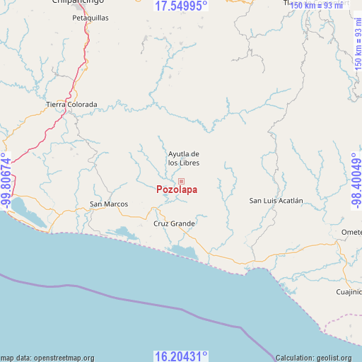
Pozolapa GPS coordinates[2]
16° 52' 41.988" North, 99° 6' 12.996" West
| Map corner | latitude | longitude |
|---|---|---|
| Upper-left | 17.54995°, | -99.80674° |
| Center: | 16.87833°, | -99.10361° |
| Lower-right: | 16.20431°, | -98.40049° |
| Map W x H: | 149.6×149.6 km | = 93×93mi |
| max Lat: | 32.7° ⇑90.7% North |
| Pozolapa: | 16.87833° |
| min Lat: | ⇓9.3% South 14.53588° |
| min Long | Pozolapa | max Long |
| -117.105° | -99.10361° | -86.73105° |
| W 48.8%⇐ | ⇒51.2% E |
Elevation
Elevation of Pozolapa is 207 m = 679 ft, and this is 1046.7 m = 3434 ft below average elevation for this country.
| Max E: |
3497 m = 11473 ft | 75.4% |
| Avg. | 1253.7 m = 4113 ft | |
| Pozolapa | 207 m = 679 ft | |
Min E: |
-1 m = -3 ft | 24.6% |
See also: Mexico elevation on elevation.city.
Geographical zone
Pozolapa is located in North Torrid zone (between Equator and Tropic of Cancer). Distance of this Northern Tropic circle is 729.2 km =453.1 mi to North.| Distance of | km | miles | from Pozolapa |
|---|---|---|---|
| North Pole | 8130.4 | 5052 | to North |
| Arctic Circle | 5524.5 | 3432.8 | to North |
| Tropic Cancer | 729.2 | 453.1 | to North |
| Equator | 1876.7 | 1166.1 | to South |


Nearby cities:
15 places around Pozolapa: (largest is in red/bold)
• Ayutla de los Libres
9.5 km =5.9 mi,  4°
4°
• Cotzalzin
5 km =3.1 mi, 4°
• El Cortijo
13.3 km =8.3 mi,  338°
338°
• El Guayabo
12.9 km =8 mi,  301°
301°
• El Mesón
6 km =3.7 mi,  127°
127°
• El Paraíso
12.5 km =7.8 mi,  61°
61°
• El Zapote
4.9 km =3 mi,  166°
166°
• La Angostura
7.8 km =4.8 mi,  91°
91°
• La Azozuca
9.1 km =5.7 mi, 133°
• La Unión
6.8 km =4.2 mi,  199°
199°
• San Antonio Abad
2.9 km =1.8 mi, 60°
• San José la Hacienda
11.9 km =7.4 mi,  19°
19°
• Tepango
2.9 km =1.8 mi,  42°
42°
• Tonalá
5.6 km =3.5 mi,  109°
109°
• Tutepec
7.4 km =4.6 mi,  310°
310°
Sources, notices
• [Note1] Compared only with cities in Mexico existing in our database
• [Src1] Map data: © OpenStreetMap contributors (CC-BY-SA)
• [Src2] Other city data from geonames.org with taken over terms of usage.
• [Src3] Geographical zone / Annual Mean Temperature by Robert A. Rohde @ Wikipedia
