La Angostura geodata
La Angostura (Guerrero) is a populated place; located in Mexico in America/Mexico_City (GMT-6) time zone. With population of 883 people, there are 9888 cities with bigger population in this country. Compared to other cities in Mexico, 90.7% of cities are located further ↑North; 50.3% of cities are located further →East and 64.2% of cities have higher elevation than La Angostura. Note1


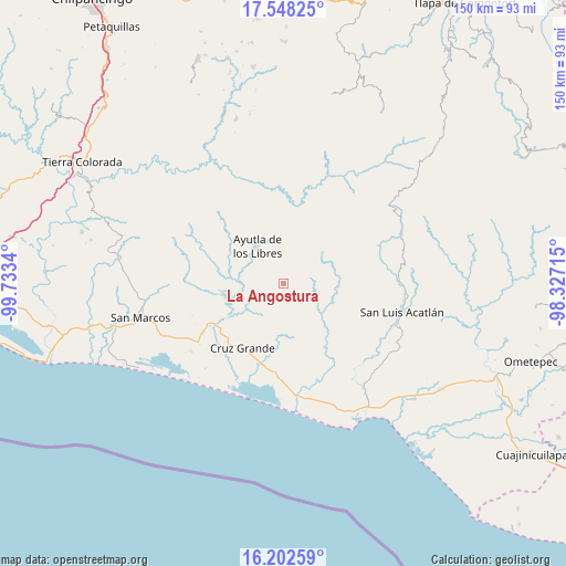
La Angostura GPS coordinates[2]
16° 52' 35.832" North, 99° 1' 48.972" West
| Map corner | latitude | longitude |
|---|---|---|
| Upper-left | 17.54825°, | -99.7334° |
| Center: | 16.87662°, | -99.03027° |
| Lower-right: | 16.20259°, | -98.32715° |
| Map W x H: | 149.6×149.6 km | = 93×93mi |
| max Lat: | 32.7° ⇑90.7% North |
| La Angostura: | 16.87662° |
| min Lat: | ⇓9.3% South 14.53588° |
| min Long | La Angostura | max Long |
| -117.105° | -99.03027° | -86.73105° |
| W 49.7%⇐ | ⇒50.3% E |
Elevation
Elevation of La Angostura is 739 m = 2425 ft, and this is 514.7 m = 1689 ft below average elevation for this country.
| Max E: |
3497 m = 11473 ft | 64.2% |
| Avg. | 1253.7 m = 4113 ft | |
| La Angostura | 739 m = 2425 ft | |
Min E: |
-1 m = -3 ft | 35.8% |
See also: Mexico elevation on elevation.city.
Geographical zone
La Angostura is located in North Torrid zone (between Equator and Tropic of Cancer). Distance of this Northern Tropic circle is 729.4 km =453.2 mi to North.| Distance of | km | miles | from La Angostura |
|---|---|---|---|
| North Pole | 8130.6 | 5052.1 | to North |
| Arctic Circle | 5524.7 | 3432.9 | to North |
| Tropic Cancer | 729.4 | 453.2 | to North |
| Equator | 1876.5 | 1166 | to South |


Nearby cities:
15 places around La Angostura: (largest is in red/bold)
• Ahuacachahue (Ndog'yo Itún Tichi)
7.2 km =4.5 mi,  138°
138°
• Ayutla de los Libres
12 km =7.5 mi,  324°
324°
• Cotzalzin
9.1 km =5.7 mi,  304°
304°
• El Mesón
4.6 km =2.9 mi,  221°
221°
• El Paraíso
6.9 km =4.3 mi,  27°
27°
• El Zapote
8.1 km =5 mi,  235°
235°
• La Azozuca
6.3 km =3.9 mi,  191°
191°
• La Concordia
6.6 km =4.1 mi,  60°
60°
• La Unión
11.9 km =7.4 mi, 238°
• Mesón Zapote
6.9 km =4.3 mi,  105°
105°
• Pozolapa
7.8 km =4.8 mi,  271°
271°
• San Antonio Abad
5.5 km =3.4 mi,  286°
286°
• San José la Hacienda
12.1 km =7.5 mi,  341°
341°
• Tepango
6.3 km =3.9 mi, 291°
• Tonalá
3.1 km =1.9 mi, 237°
Sources, notices
• [Note1] Compared only with cities in Mexico existing in our database
• [Src1] Map data: © OpenStreetMap contributors (CC-BY-SA)
• [Src2] Other city data from geonames.org with taken over terms of usage.
• [Src3] Geographical zone / Annual Mean Temperature by Robert A. Rohde @ Wikipedia
