San Antonio Abad geodata
San Antonio Abad (Guerrero) is a populated place; located in Mexico in America/Mexico_City (GMT-6) time zone. With population of 687 people, there are 12648 cities with bigger population in this country. Compared to other cities in Mexico, 90.4% of cities are located further ↑North; 50.9% of cities are located further →East and 72.2% of cities have higher elevation than San Antonio Abad. Note1


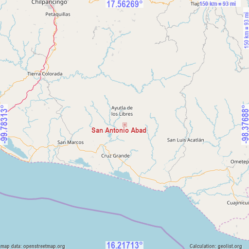
San Antonio Abad GPS coordinates[2]
16° 53' 27.996" North, 99° 4' 48" West
| Map corner | latitude | longitude |
|---|---|---|
| Upper-left | 17.56269°, | -99.78313° |
| Center: | 16.89111°, | -99.08° |
| Lower-right: | 16.21713°, | -98.37688° |
| Map W x H: | 149.6×149.6 km | = 93×93mi |
| max Lat: | 32.7° ⇑90.4% North |
| San Antonio Abad: | 16.89111° |
| min Lat: | ⇓9.6% South 14.53588° |
| min Long | San Antonio Aba | max Long |
| -117.105° | -99.08° | -86.73105° |
| W 49.1%⇐ | ⇒50.9% E |
Elevation
Elevation of San Antonio Abad is 321 m = 1053 ft, and this is 932.7 m = 3060 ft below average elevation for this country.
| Max E: |
3497 m = 11473 ft | 72.2% |
| Avg. | 1253.7 m = 4113 ft | |
| San Antonio Abad | 321 m = 1053 ft | |
Min E: |
-1 m = -3 ft | 27.8% |
See also: Mexico elevation on elevation.city.
Geographical zone
San Antonio Abad is located in North Torrid zone (between Equator and Tropic of Cancer). Distance of this Northern Tropic circle is 727.8 km =452.2 mi to North.| Distance of | km | miles | from San Antonio Abad |
|---|---|---|---|
| North Pole | 8128.9 | 5051.1 | to North |
| Arctic Circle | 5523.1 | 3431.9 | to North |
| Tropic Cancer | 727.8 | 452.2 | to North |
| Equator | 1878.1 | 1167 | to South |


Nearby cities:
15 places around San Antonio Abad: (largest is in red/bold)
• Ahuacachahue (Ndog'yo Itún Tichi)
12.2 km =7.6 mi,  124°
124°
• Ayutla de los Libres
8.3 km =5.2 mi,  347°
347°
• Cotzalzin
4.2 km =2.6 mi,  328°
328°
• El Mesón
5.5 km =3.4 mi,  155°
155°
• El Paraíso
9.6 km =6 mi,  61°
61°
• El Zapote
6.3 km =3.9 mi,  192°
192°
• La Angostura
5.5 km =3.4 mi,  106°
106°
• La Azozuca
8.7 km =5.4 mi,  152°
152°
• La Concordia
11.2 km =7 mi,  81°
81°
• La Unión
9.2 km =5.7 mi,  211°
211°
• Pozolapa
2.9 km =1.8 mi,  240°
240°
• San José la Hacienda
9.9 km =6.2 mi,  8°
8°
• Tepango
0.9 km =0.6 mi,  324°
324°
• Tonalá
4.3 km =2.7 mi,  140°
140°
• Tutepec
8.8 km =5.5 mi,  292°
292°
Sources, notices
• [Note1] Compared only with cities in Mexico existing in our database
• [Src1] Map data: © OpenStreetMap contributors (CC-BY-SA)
• [Src2] Other city data from geonames.org with taken over terms of usage.
• [Src3] Geographical zone / Annual Mean Temperature by Robert A. Rohde @ Wikipedia
