La Unión geodata
La Unión (Guerrero) is a populated place; located in Mexico in America/Mexico_City (GMT-6) time zone. With population of 897 people, there are 9721 cities with bigger population in this country. Compared to other cities in Mexico, 91.4% of cities are located further ↑North; 51.5% of cities are located further →East and 81.5% of cities have higher elevation than La Unión. Note1


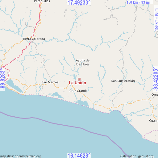
La Unión GPS coordinates[2]
16° 49' 13.8" North, 99° 7' 30.612" West
| Map corner | latitude | longitude |
|---|---|---|
| Upper-left | 17.49233°, | -99.8283° |
| Center: | 16.8205°, | -99.12517° |
| Lower-right: | 16.14628°, | -98.42205° |
| Map W x H: | 149.7×149.7 km | = 93×93mi |
| max Lat: | 32.7° ⇑91.4% North |
| La Unión: | 16.8205° |
| min Lat: | ⇓8.6% South 14.53588° |
| min Long | La Unión | max Long |
| -117.105° | -99.12517° | -86.73105° |
| W 48.5%⇐ | ⇒51.5% E |
Elevation
Elevation of La Unión is 76 m = 249 ft, and this is 1177.7 m = 3864 ft below average elevation for this country.
| Max E: |
3497 m = 11473 ft | 81.5% |
| Avg. | 1253.7 m = 4113 ft | |
| La Unión | 76 m = 249 ft | |
Min E: |
-1 m = -3 ft | 18.5% |
See also: Mexico elevation on elevation.city.
Geographical zone
La Unión is located in North Torrid zone (between Equator and Tropic of Cancer). Distance of this Northern Tropic circle is 735.7 km =457.1 mi to North.| Distance of | km | miles | from La Unión |
|---|---|---|---|
| North Pole | 8136.8 | 5056 | to North |
| Arctic Circle | 5530.9 | 3436.7 | to North |
| Tropic Cancer | 735.7 | 457.1 | to North |
| Equator | 1870.3 | 1162.2 | to South |


Nearby cities:
15 places around La Unión: (largest is in red/bold)
• Cotzalzin
11.7 km =7.3 mi,  13°
13°
• Cruz Grande
10.9 km =6.8 mi,  179°
179°
• El Mesón
7.6 km =4.7 mi,  68°
68°
• El Porvenir
9 km =5.6 mi,  235°
235°
• El Zapote
3.8 km =2.4 mi,  63°
63°
• La Angostura
11.9 km =7.4 mi, 58°
• La Azozuca
8.9 km =5.5 mi,  89°
89°
• La Dicha
13.6 km =8.5 mi,  115°
115°
• Las Vigas
12.9 km =8 mi, 239°
• Llano Grande
10.6 km =6.6 mi,  209°
209°
• Pozolapa
6.8 km =4.2 mi,  19°
19°
• San Antonio Abad
9.2 km =5.7 mi,  31°
31°
• Tepango
9.6 km =6 mi, 26°
• Tonalá
8.8 km =5.5 mi, 58°
• Tutepec
11.7 km =7.3 mi,  343°
343°
Sources, notices
• [Note1] Compared only with cities in Mexico existing in our database
• [Src1] Map data: © OpenStreetMap contributors (CC-BY-SA)
• [Src2] Other city data from geonames.org with taken over terms of usage.
• [Src3] Geographical zone / Annual Mean Temperature by Robert A. Rohde @ Wikipedia
