Cotzalzin geodata
Cotzalzin (Guerrero) is a populated place; located in Mexico in America/Mexico_City (GMT-6) time zone. With population of 717 people, there are 12151 cities with bigger population in this country. Compared to other cities in Mexico, 90% of cities are located further ↑North; 51.1% of cities are located further →East and 72.7% of cities have higher elevation than Cotzalzin. Note1


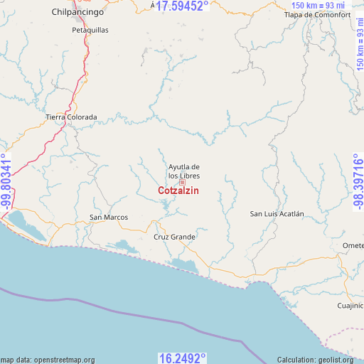
Cotzalzin GPS coordinates[2]
16° 55' 23.016" North, 99° 6' 1.008" West
| Map corner | latitude | longitude |
|---|---|---|
| Upper-left | 17.59452°, | -99.80341° |
| Center: | 16.92306°, | -99.10028° |
| Lower-right: | 16.2492°, | -98.39716° |
| Map W x H: | 149.6×149.6 km | = 93×93mi |
| max Lat: | 32.7° ⇑90% North |
| Cotzalzin: | 16.92306° |
| min Lat: | ⇓10% South 14.53588° |
| min Long | Cotzalzin | max Long |
| -117.105° | -99.10028° | -86.73105° |
| W 48.9%⇐ | ⇒51.1% E |
Elevation
Elevation of Cotzalzin is 304 m = 997 ft, and this is 949.7 m = 3116 ft below average elevation for this country.
| Max E: |
3497 m = 11473 ft | 72.7% |
| Avg. | 1253.7 m = 4113 ft | |
| Cotzalzin | 304 m = 997 ft | |
Min E: |
-1 m = -3 ft | 27.3% |
See also: Mexico elevation on elevation.city.
Geographical zone
Cotzalzin is located in North Torrid zone (between Equator and Tropic of Cancer). Distance of this Northern Tropic circle is 724.3 km =450.1 mi to North.| Distance of | km | miles | from Cotzalzin |
|---|---|---|---|
| North Pole | 8125.4 | 5048.9 | to North |
| Arctic Circle | 5519.5 | 3429.7 | to North |
| Tropic Cancer | 724.3 | 450.1 | to North |
| Equator | 1881.7 | 1169.2 | to South |


Nearby cities:
15 places around Cotzalzin: (largest is in red/bold)
• Ayutla de los Libres
4.5 km =2.8 mi,  5°
5°
• Cruz Quemada
11.8 km =7.3 mi,  314°
314°
• El Cortijo
9 km =5.6 mi,  325°
325°
• El Guayabo
11.5 km =7.1 mi,  279°
279°
• El Mesón
9.7 km =6 mi,  152°
152°
• El Paraíso
10.6 km =6.6 mi,  84°
84°
• El Zapote
9.7 km =6 mi,  175°
175°
• La Angostura
9.1 km =5.7 mi,  124°
124°
• La Unión
11.7 km =7.3 mi,  193°
193°
• Pozolapa
5 km =3.1 mi, 184°
• San Antonio Abad
4.2 km =2.6 mi, 148°
• San José la Hacienda
7.2 km =4.5 mi,  29°
29°
• Tepango
3.3 km =2.1 mi, 149°
• Tonalá
8.4 km =5.2 mi,  144°
144°
• Tutepec
6 km =3.7 mi,  268°
268°
Sources, notices
• [Note1] Compared only with cities in Mexico existing in our database
• [Src1] Map data: © OpenStreetMap contributors (CC-BY-SA)
• [Src2] Other city data from geonames.org with taken over terms of usage.
• [Src3] Geographical zone / Annual Mean Temperature by Robert A. Rohde @ Wikipedia
