Primer Cantón geodata
Primer Cantón (Chiapas) is a populated place; located in Mexico in America/Mexico_City (GMT-6) time zone. With population of 1,477 people, there are 5846 cities with bigger population in this country. Compared to other cities in Mexico, 99.1% of cities are located further ↑North; 92.4% of cities are located further ←West and 85.5% of cities have higher elevation than Primer Cantón. Note1


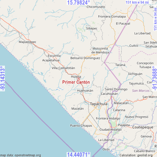
Primer Cantón GPS coordinates[2]
15° 7' 14.016" North, 92° 26' 24" West
| Map corner | latitude | longitude |
|---|---|---|
| Upper-left | 15.79824°, | -93.14313° |
| Center: | 15.12056°, | -92.44° |
| Lower-right: | 14.44071°, | -91.73688° |
| Map W x H: | 150.9×150.9 km | = 93.8×93.8mi |
| max Lat: | 32.7° ⇑99.1% North |
| Primer Cantón: | 15.12056° |
| min Lat: | ⇓0.9% South 14.53588° |
| min Long | Primer Cantón | max Long |
| -117.105° | -92.44° | -86.73105° |
| W 92.4%⇐ | ⇒7.6% E |
Elevation
Elevation of Primer Cantón is 41 m = 135 ft, and this is 1212.7 m = 3979 ft below average elevation for this country.
| Max E: |
3497 m = 11473 ft | 85.5% |
| Avg. | 1253.7 m = 4113 ft | |
| Primer Cantón | 41 m = 135 ft | |
Min E: |
-1 m = -3 ft | 14.5% |
See also: Mexico elevation on elevation.city.
Geographical zone
Primer Cantón is located in North Torrid zone (between Equator and Tropic of Cancer). Distance of this Northern Tropic circle is 924.7 km =574.6 mi to North.| Distance of | km | miles | from Primer Cantón |
|---|---|---|---|
| North Pole | 8325.8 | 5173.4 | to North |
| Arctic Circle | 5719.9 | 3554.2 | to North |
| Tropic Cancer | 924.7 | 574.6 | to North |
| Equator | 1681.2 | 1044.6 | to South |


Nearby cities:
15 places around Primer Cantón: (largest is in red/bold)
• Aquiles Serdán
5.7 km =3.5 mi,  317°
317°
• Cantón las Delicias
6.8 km =4.2 mi,  252°
252°
• Colonia Obrera
6.7 km =4.2 mi, 248°
• Cuarto Cantón
3.3 km =2.1 mi,  184°
184°
• El Arenal
6.4 km =4 mi,  230°
230°
• El Chipilín
1.4 km =0.9 mi,  90°
90°
• Estación Tuzantán
2 km =1.2 mi,  216°
216°
• Francisco Sarabia 1ra. Sección
5.8 km =3.6 mi,  42°
42°
• Guadalupe Victoria
6 km =3.7 mi, 37°
• Huixtla
3.3 km =2.1 mi,  308°
308°
• La Flor
3 km =1.9 mi,  355°
355°
• Segundo Cantón
2.3 km =1.4 mi,  167°
167°
• Tuzantán
3.5 km =2.2 mi,  32°
32°
• Veintinueve de Diciembre
2.8 km =1.7 mi,  334°
334°
• Xochiltepec
1 km =0.6 mi, 39°
Sources, notices
• [Note1] Compared only with cities in Mexico existing in our database
• [Src1] Map data: © OpenStreetMap contributors (CC-BY-SA)
• [Src2] Other city data from geonames.org with taken over terms of usage.
• [Src3] Geographical zone / Annual Mean Temperature by Robert A. Rohde @ Wikipedia
