Atrixco geodata
Atrixco (Guerrero) is a populated place; located in Mexico in America/Mexico_City (GMT-6) time zone. With population of 876 people, there are 9971 cities with bigger population in this country. Compared to other cities in Mexico, 93.4% of cities are located further ↑North; 51.3% of cities are located further ←West and 85.3% of cities have higher elevation than Atrixco. Note1


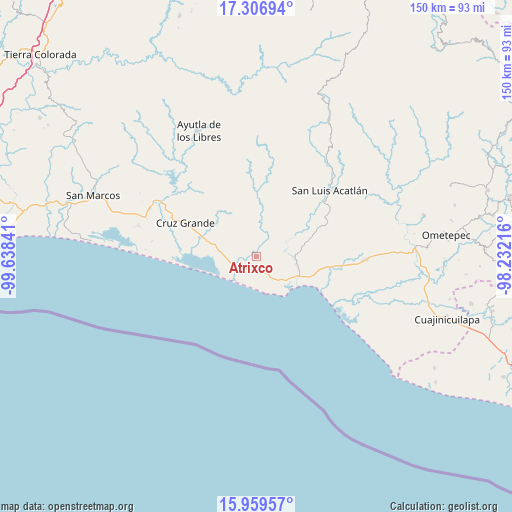
Atrixco GPS coordinates[2]
16° 38' 3.984" North, 98° 56' 7.008" West
| Map corner | latitude | longitude |
|---|---|---|
| Upper-left | 17.30694°, | -99.63841° |
| Center: | 16.63444°, | -98.93528° |
| Lower-right: | 15.95957°, | -98.23216° |
| Map W x H: | 149.8×149.8 km | = 93.1×93.1mi |
| max Lat: | 32.7° ⇑93.4% North |
| Atrixco: | 16.63444° |
| min Lat: | ⇓6.6% South 14.53588° |
| min Long | Atrixco | max Long |
| -117.105° | -98.93528° | -86.73105° |
| W 51.3%⇐ | ⇒48.7% E |
Elevation
Elevation of Atrixco is 42 m = 138 ft, and this is 1211.7 m = 3975 ft below average elevation for this country.
| Max E: |
3497 m = 11473 ft | 85.3% |
| Avg. | 1253.7 m = 4113 ft | |
| Atrixco | 42 m = 138 ft | |
Min E: |
-1 m = -3 ft | 14.7% |
See also: Mexico elevation on elevation.city.
Geographical zone
Atrixco is located in North Torrid zone (between Equator and Tropic of Cancer). Distance of this Northern Tropic circle is 756.3 km =469.9 mi to North.| Distance of | km | miles | from Atrixco |
|---|---|---|---|
| North Pole | 8157.5 | 5068.8 | to North |
| Arctic Circle | 5551.6 | 3449.6 | to North |
| Tropic Cancer | 756.3 | 469.9 | to North |
| Equator | 1849.6 | 1149.3 | to South |


Nearby cities:
15 places around Atrixco: (largest is in red/bold)
• Chautengo
16.7 km =10.4 mi,  272°
272°
• Copala
5.5 km =3.4 mi,  237°
237°
• Cuautepec
14.7 km =9.1 mi,  330°
330°
• El Carrizo
9.8 km =6.1 mi, 272°
• El Coquillo
10.2 km =6.3 mi,  2°
2°
• El Llano
7.3 km =4.5 mi,  344°
344°
• El Pabellón
9.8 km =6.1 mi,  298°
298°
• El Polvorín
15.6 km =9.7 mi,  113°
113°
• El Salto
8.5 km =5.3 mi,  310°
310°
• Huamuchititán (El Huamuchito)
12.7 km =7.9 mi,  349°
349°
• Islaltepec (Las Parotas)
11.9 km =7.4 mi,  121°
121°
• Jalapa
15.5 km =9.6 mi, 304°
• Las Peñas
13.2 km =8.2 mi, 269°
• Marquelia
13.8 km =8.6 mi, 114°
• Tepantitlán
11.2 km =7 mi,  91°
91°
Sources, notices
• [Note1] Compared only with cities in Mexico existing in our database
• [Src1] Map data: © OpenStreetMap contributors (CC-BY-SA)
• [Src2] Other city data from geonames.org with taken over terms of usage.
• [Src3] Geographical zone / Annual Mean Temperature by Robert A. Rohde @ Wikipedia
