Tacotalpa geodata
Tacotalpa (Tabasco) is a seat of a second-order administrative division; located in Mexico in America/Mexico_City (GMT-6) time zone. With population of 8,071 people, there are 1173 cities with bigger population in this country. Compared to other cities in Mexico, 82.2% of cities are located further ↑North; 89.7% of cities are located further ←West and 90% of cities have higher elevation than Tacotalpa. Note1


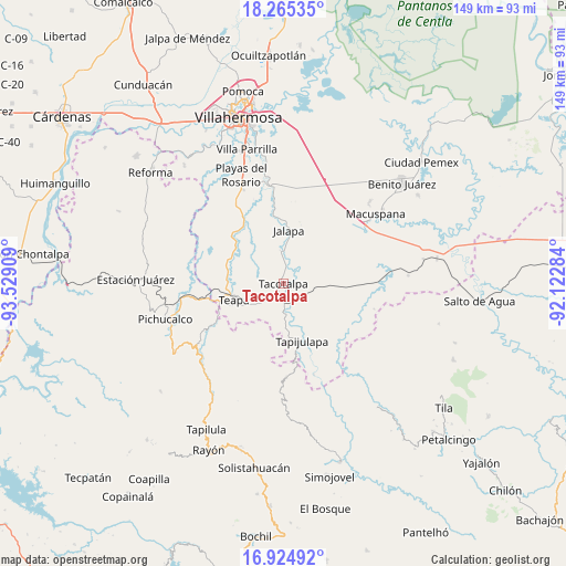
Tacotalpa GPS coordinates[2]
17° 35' 46.968" North, 92° 49' 33.456" West
| Map corner | latitude | longitude |
|---|---|---|
| Upper-left | 18.26535°, | -93.52909° |
| Center: | 17.59638°, | -92.82596° |
| Lower-right: | 16.92492°, | -92.12284° |
| Map W x H: | 149×149 km | = 92.6×92.6mi |
| max Lat: | 32.7° ⇑82.2% North |
| Tacotalpa: | 17.59638° |
| min Lat: | ⇓17.8% South 14.53588° |
| min Long | Tacotalpa | max Long |
| -117.105° | -92.82596° | -86.73105° |
| W 89.7%⇐ | ⇒10.3% E |
Elevation
Elevation of Tacotalpa is 24 m = 79 ft, and this is 1229.7 m = 4034 ft below average elevation for this country.
| Max E: |
3497 m = 11473 ft | 90% |
| Avg. | 1253.7 m = 4113 ft | |
| Tacotalpa | 24 m = 79 ft | |
Min E: |
-1 m = -3 ft | 10% |
See also: Mexico elevation on elevation.city.
Geographical zone
Tacotalpa is located in North Torrid zone (between Equator and Tropic of Cancer). Distance of this Northern Tropic circle is 649.4 km =403.5 mi to North.| Distance of | km | miles | from Tacotalpa |
|---|---|---|---|
| North Pole | 8050.5 | 5002.3 | to North |
| Arctic Circle | 5444.6 | 3383.1 | to North |
| Tropic Cancer | 649.4 | 403.5 | to North |
| Equator | 1956.5 | 1215.7 | to South |


Nearby cities:
15 places around Tacotalpa: (largest is in red/bold)
• Calicanto 2da. Sección
15.7 km =9.8 mi,  52°
52°
• Ceiba 2da. Sección (San Luis)
2.6 km =1.6 mi,  249°
249°
• Chapultepec
16 km =9.9 mi,  257°
257°
• Eureka y Belén
11.7 km =7.3 mi, 249°
• Jahuacapa
15.8 km =9.8 mi,  357°
357°
• Jalapa
14 km =8.7 mi,  5°
5°
• José María Morelos y Pavón (Las Delicias)
12.3 km =7.6 mi,  291°
291°
• Manuel Buelta 2da. Sección
14.8 km =9.2 mi, 262°
• Pochitocal 1ra. Sección (La Palma)
9.4 km =5.8 mi,  67°
67°
• San Ramón
2.4 km =1.5 mi,  157°
157°
• Tapijulapa
15.7 km =9.8 mi, 161°
• Teapa
14.3 km =8.9 mi, 248°
• Vicente Guerrero
13.8 km =8.6 mi,  227°
227°
• Xicoténcatl
15.5 km =9.6 mi,  124°
124°
• Zunu y Patastal
13.7 km =8.5 mi,  174°
174°
Sources, notices
• [Note1] Compared only with cities in Mexico existing in our database
• [Src1] Map data: © OpenStreetMap contributors (CC-BY-SA)
• [Src2] Other city data from geonames.org with taken over terms of usage.
• [Src3] Geographical zone / Annual Mean Temperature by Robert A. Rohde @ Wikipedia
