San Ramón geodata
San Ramón (Tabasco) is a populated place; located in Mexico in America/Mexico_City (GMT-6) time zone. With population of 662 people, there are 13120 cities with bigger population in this country. Compared to other cities in Mexico, 82.4% of cities are located further ↑North; 89.7% of cities are located further ←West and 89.4% of cities have higher elevation than San Ramón. Note1


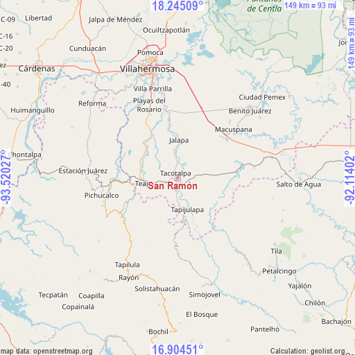
San Ramón GPS coordinates[2]
17° 34' 33.744" North, 92° 49' 1.704" West
| Map corner | latitude | longitude |
|---|---|---|
| Upper-left | 18.24509°, | -93.52027° |
| Center: | 17.57604°, | -92.81714° |
| Lower-right: | 16.90451°, | -92.11402° |
| Map W x H: | 149.1×149.1 km | = 92.6×92.6mi |
| max Lat: | 32.7° ⇑82.4% North |
| San Ramón: | 17.57604° |
| min Lat: | ⇓17.6% South 14.53588° |
| min Long | San Ramón | max Long |
| -117.105° | -92.81714° | -86.73105° |
| W 89.7%⇐ | ⇒10.3% E |
Elevation
Elevation of San Ramón is 26 m = 85 ft, and this is 1227.7 m = 4028 ft below average elevation for this country.
| Max E: |
3497 m = 11473 ft | 89.4% |
| Avg. | 1253.7 m = 4113 ft | |
| San Ramón | 26 m = 85 ft | |
Min E: |
-1 m = -3 ft | 10.6% |
See also: Mexico elevation on elevation.city.
Geographical zone
San Ramón is located in North Torrid zone (between Equator and Tropic of Cancer). Distance of this Northern Tropic circle is 651.6 km =404.9 mi to North.| Distance of | km | miles | from San Ramón |
|---|---|---|---|
| North Pole | 8052.8 | 5003.8 | to North |
| Arctic Circle | 5446.9 | 3384.5 | to North |
| Tropic Cancer | 651.6 | 404.9 | to North |
| Equator | 1954.3 | 1214.3 | to South |


Nearby cities:
15 places around San Ramón: (largest is in red/bold)
• Calicanto 2da. Sección
16.5 km =10.3 mi,  43°
43°
• Ceiba 2da. Sección (San Luis)
3.6 km =2.2 mi,  292°
292°
• Chapultepec
16.6 km =10.3 mi,  265°
265°
• Eureka y Belén
12 km =7.5 mi,  261°
261°
• Jalapa
16.2 km =10.1 mi,  1°
1°
• José María Morelos y Pavón (Las Delicias)
14.1 km =8.8 mi,  298°
298°
• Manuel Buelta 2da. Sección
15.6 km =9.7 mi, 271°
• Mariano Abasolo
16.4 km =10.2 mi, 258°
• Pochitocal 1ra. Sección (La Palma)
9.7 km =6 mi,  52°
52°
• Tacotalpa
2.4 km =1.5 mi,  337°
337°
• Tapijulapa
13.3 km =8.3 mi,  162°
162°
• Teapa
14.6 km =9.1 mi, 258°
• Vicente Guerrero
13.2 km =8.2 mi,  237°
237°
• Xicoténcatl
13.5 km =8.4 mi,  118°
118°
• Zunu y Patastal
11.4 km =7.1 mi,  177°
177°
Sources, notices
• [Note1] Compared only with cities in Mexico existing in our database
• [Src1] Map data: © OpenStreetMap contributors (CC-BY-SA)
• [Src2] Other city data from geonames.org with taken over terms of usage.
• [Src3] Geographical zone / Annual Mean Temperature by Robert A. Rohde @ Wikipedia
