Cuauhtémoc geodata
Cuauhtémoc (Veracruz) is a populated place; located in Mexico in America/Mexico_City (GMT-6) time zone. With population of 777 people, there are 11245 cities with bigger population in this country. Compared to other cities in Mexico, 67.6% of cities are located further ↑North; 76.1% of cities are located further ←West and 64.2% of cities have higher elevation than Cuauhtémoc. Note1


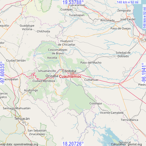
Cuauhtémoc GPS coordinates[2]
18° 52' 26.004" North, 96° 53' 49.992" West
| Map corner | latitude | longitude |
|---|---|---|
| Upper-left | 19.53788°, | -97.60035° |
| Center: | 18.87389°, | -96.89722° |
| Lower-right: | 18.20726°, | -96.1941° |
| Map W x H: | 148×148 km | = 92×92mi |
| max Lat: | 32.7° ⇑67.6% North |
| Cuauhtémoc: | 18.87389° |
| min Lat: | ⇓32.4% South 14.53588° |
| min Long | Cuauhtémoc | max Long |
| -117.105° | -96.89722° | -86.73105° |
| W 76.1%⇐ | ⇒23.9% E |
Elevation
Elevation of Cuauhtémoc is 739 m = 2425 ft, and this is 514.7 m = 1689 ft below average elevation for this country.
| Max E: |
3497 m = 11473 ft | 64.2% |
| Avg. | 1253.7 m = 4113 ft | |
| Cuauhtémoc | 739 m = 2425 ft | |
Min E: |
-1 m = -3 ft | 35.8% |
See also: Mexico elevation on elevation.city.
Geographical zone
Cuauhtémoc is located in North Torrid zone (between Equator and Tropic of Cancer). Distance of this Northern Tropic circle is 507.3 km =315.2 mi to North.| Distance of | km | miles | from Cuauhtémoc |
|---|---|---|---|
| North Pole | 7908.5 | 4914.1 | to North |
| Arctic Circle | 5302.6 | 3294.9 | to North |
| Tropic Cancer | 507.3 | 315.2 | to North |
| Equator | 2098.6 | 1304 | to South |


Nearby cities:
15 places around Cuauhtémoc: (largest is in red/bold)
• Agustín Millán
2.8 km =1.7 mi,  298°
298°
• Amatlán de los Reyes
3.6 km =2.2 mi,  212°
212°
• Berlín
5.6 km =3.5 mi,  332°
332°
• Centro de Readaptación Social
6 km =3.7 mi,  228°
228°
• Córdoba
3.2 km =2 mi,  291°
291°
• El Porvenir
6 km =3.7 mi, 330°
• Manuel León
3.5 km =2.2 mi,  129°
129°
• Paraje Nuevo
3.9 km =2.4 mi,  81°
81°
• Peñuela
1.1 km =0.7 mi,  158°
158°
• Potrero Viejo
5.7 km =3.5 mi,  86°
86°
• San Matías
5.2 km =3.2 mi, 326°
• San Rafael Río Seco
1.7 km =1.1 mi, 81°
• Trapiche Viejo
6.1 km =3.8 mi,  236°
236°
• Venta Parada
5.6 km =3.5 mi,  116°
116°
• Zacatepec
5.5 km =3.4 mi,  270°
270°
Sources, notices
• [Note1] Compared only with cities in Mexico existing in our database
• [Src1] Map data: © OpenStreetMap contributors (CC-BY-SA)
• [Src2] Other city data from geonames.org with taken over terms of usage.
• [Src3] Geographical zone / Annual Mean Temperature by Robert A. Rohde @ Wikipedia
