Tepozonalco geodata
Tepozonalco (Guerrero) is a populated place; located in Mexico in America/Mexico_City (GMT-6) time zone. With population of 593 people, there are 14492 cities with bigger population in this country. Compared to other cities in Mexico, 82.4% of cities are located further ↑North; 50.3% of cities are located further →East and 57.4% of cities have lower elevation than Tepozonalco. Note1


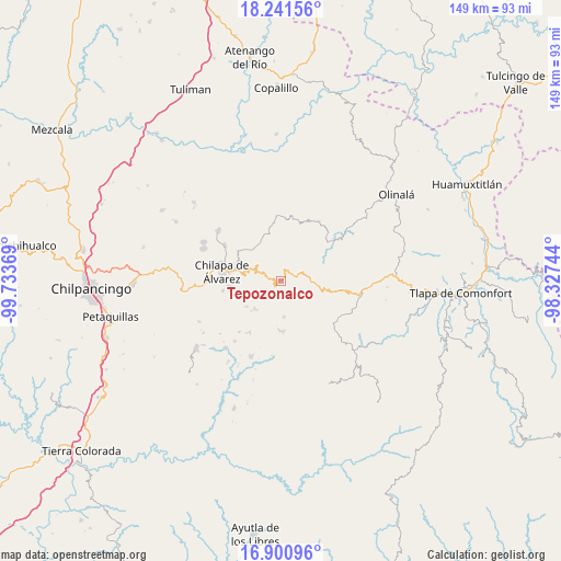
Tepozonalco GPS coordinates[2]
17° 34' 21" North, 99° 1' 50.016" West
| Map corner | latitude | longitude |
|---|---|---|
| Upper-left | 18.24156°, | -99.73369° |
| Center: | 17.5725°, | -99.03056° |
| Lower-right: | 16.90096°, | -98.32744° |
| Map W x H: | 149.1×149.1 km | = 92.6×92.6mi |
| max Lat: | 32.7° ⇑82.4% North |
| Tepozonalco: | 17.5725° |
| min Lat: | ⇓17.6% South 14.53588° |
| min Long | Tepozonalco | max Long |
| -117.105° | -99.03056° | -86.73105° |
| W 49.7%⇐ | ⇒50.3% E |
Elevation
Elevation of Tepozonalco is 1673 m = 5489 ft, and this is 419.3 m = 1376 ft above average elevation for this country.
| Max E: |
3497 m = 11473 ft | 42.6% |
| Tepozonalco | 1673 m 5489 ft | |
| Avg. | 1253.7 m = 4113 ft | |
Min E: |
-1 m = -3 ft | 57.4% |
See also: Mexico elevation on elevation.city.
Geographical zone
Tepozonalco is located in North Torrid zone (between Equator and Tropic of Cancer). Distance of this Northern Tropic circle is 652 km =405.1 mi to North.| Distance of | km | miles | from Tepozonalco |
|---|---|---|---|
| North Pole | 8053.2 | 5004 | to North |
| Arctic Circle | 5447.3 | 3384.8 | to North |
| Tropic Cancer | 652 | 405.1 | to North |
| Equator | 1953.9 | 1214.1 | to South |


Nearby cities:
15 places around Tepozonalco: (largest is in red/bold)
• Agua Zarca
12.3 km =7.6 mi,  281°
281°
• Ahuixtla
4.7 km =2.9 mi,  187°
187°
• Alcozacán
10.2 km =6.3 mi,  222°
222°
• Atlixtac
10.3 km =6.4 mi,  95°
95°
• Atzacoaloya
11.7 km =7.3 mi,  255°
255°
• Oztotitlán
11.1 km =6.9 mi,  3°
3°
• Pantitlán
11.2 km =7 mi,  311°
311°
• Petatlán
4.4 km =2.7 mi,  77°
77°
• San Jerónimo Palantla
7.9 km =4.9 mi,  231°
231°
• Santa Cruz
12.7 km =7.9 mi, 312°
• Tecoanapa
11.4 km =7.1 mi,  353°
353°
• Tepetlacingo
12.3 km =7.6 mi, 264°
• Tlachimaltepec
9.9 km =6.2 mi,  169°
169°
• Trigomila
10.6 km =6.6 mi, 276°
• Zompeltepec
3.7 km =2.3 mi,  248°
248°
Sources, notices
• [Note1] Compared only with cities in Mexico existing in our database
• [Src1] Map data: © OpenStreetMap contributors (CC-BY-SA)
• [Src2] Other city data from geonames.org with taken over terms of usage.
• [Src3] Geographical zone / Annual Mean Temperature by Robert A. Rohde @ Wikipedia
