Palzoquitla geodata
Palzoquitla (Puebla) is a populated place; located in Mexico in America/Mexico_City (GMT-6) time zone. With population of 746 people, there are 11739 cities with bigger population in this country. Compared to other cities in Mexico, 59.5% of cities are located further ↓South; 63.9% of cities are located further ←West and 55.9% of cities have lower elevation than Palzoquitla. Note1


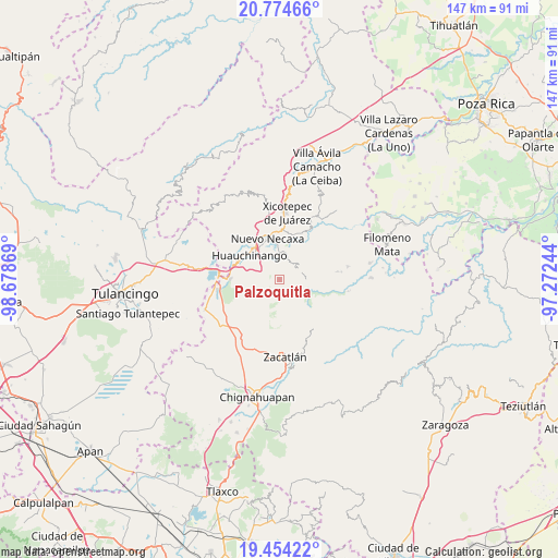
Palzoquitla GPS coordinates[2]
20° 6' 56.988" North, 97° 58' 32.016" West
| Map corner | latitude | longitude |
|---|---|---|
| Upper-left | 20.77466°, | -98.67869° |
| Center: | 20.11583°, | -97.97556° |
| Lower-right: | 19.45422°, | -97.27244° |
| Map W x H: | 146.8×146.8 km | = 91.2×91.2mi |
| max Lat: | 32.7° ⇑40.5% North |
| Palzoquitla: | 20.11583° |
| min Lat: | ⇓59.5% South 14.53588° |
| min Long | Palzoquitla | max Long |
| -117.105° | -97.97556° | -86.73105° |
| W 63.9%⇐ | ⇒36.1% E |
Elevation
Elevation of Palzoquitla is 1616 m = 5302 ft, and this is 362.3 m = 1189 ft above average elevation for this country.
| Max E: |
3497 m = 11473 ft | 44.1% |
| Palzoquitla | 1616 m 5302 ft | |
| Avg. | 1253.7 m = 4113 ft | |
Min E: |
-1 m = -3 ft | 55.9% |
See also: Mexico elevation on elevation.city.
Geographical zone
Palzoquitla is located in North Torrid zone (between Equator and Tropic of Cancer). Distance of this Northern Tropic circle is 369.2 km =229.4 mi to North.| Distance of | km | miles | from Palzoquitla |
|---|---|---|---|
| North Pole | 7770.4 | 4828.3 | to North |
| Arctic Circle | 5164.5 | 3209.1 | to North |
| Tropic Cancer | 369.2 | 229.4 | to North |
| Equator | 2236.7 | 1389.8 | to South |


Nearby cities:
15 places around Palzoquitla: (largest is in red/bold)
• Ahuacatlán
4.1 km =2.5 mi,  305°
305°
• Chicahuaxtla
4.3 km =2.7 mi,  46°
46°
• Chiconcuautla
4.5 km =2.8 mi,  121°
121°
• Ocpaco
7.1 km =4.4 mi,  298°
298°
• Papatlazolco
7.1 km =4.4 mi,  346°
346°
• San Lorenzo Tlaxipehuala
1.6 km =1 mi,  7°
7°
• Tlalmaya
4.8 km =3 mi, 348°
• Tlaltenango
1.5 km =0.9 mi,  83°
83°
• Tlaola
6 km =3.7 mi,  65°
65°
• Tlaxco (Santiago Tlaxco)
6.6 km =4.1 mi,  168°
168°
• Toxtla
6.2 km =3.9 mi,  151°
151°
• Xaltepec
6.1 km =3.8 mi,  333°
333°
• Xaltepuxtla
6.6 km =4.1 mi,  3°
3°
• Xilocuautla
5.6 km =3.5 mi, 297°
• Zempoala
4 km =2.5 mi,  216°
216°
Sources, notices
• [Note1] Compared only with cities in Mexico existing in our database
• [Src1] Map data: © OpenStreetMap contributors (CC-BY-SA)
• [Src2] Other city data from geonames.org with taken over terms of usage.
• [Src3] Geographical zone / Annual Mean Temperature by Robert A. Rohde @ Wikipedia
