Ocpaco geodata
Ocpaco (Puebla) is a populated place; located in Mexico in America/Mexico_City (GMT-6) time zone. With population of 864 people, there are 10127 cities with bigger population in this country. Compared to other cities in Mexico, 60.2% of cities are located further ↓South; 63.2% of cities are located further ←West and 57.4% of cities have lower elevation than Ocpaco. Note1


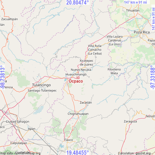
Ocpaco GPS coordinates[2]
20° 8' 45.744" North, 98° 2' 6" West
| Map corner | latitude | longitude |
|---|---|---|
| Upper-left | 20.80474°, | -98.73813° |
| Center: | 20.14604°, | -98.035° |
| Lower-right: | 19.48455°, | -97.33188° |
| Map W x H: | 146.8×146.8 km | = 91.2×91.2mi |
| max Lat: | 32.7° ⇑39.8% North |
| Ocpaco: | 20.14604° |
| min Lat: | ⇓60.2% South 14.53588° |
| min Long | Ocpaco | max Long |
| -117.105° | -98.035° | -86.73105° |
| W 63.2%⇐ | ⇒36.8% E |
Elevation
Elevation of Ocpaco is 1672 m = 5486 ft, and this is 418.3 m = 1372 ft above average elevation for this country.
| Max E: |
3497 m = 11473 ft | 42.6% |
| Ocpaco | 1672 m 5486 ft | |
| Avg. | 1253.7 m = 4113 ft | |
Min E: |
-1 m = -3 ft | 57.4% |
See also: Mexico elevation on elevation.city.
Geographical zone
Ocpaco is located in North Torrid zone (between Equator and Tropic of Cancer). Distance of this Northern Tropic circle is 365.9 km =227.4 mi to North.| Distance of | km | miles | from Ocpaco |
|---|---|---|---|
| North Pole | 7767 | 4826.2 | to North |
| Arctic Circle | 5161.1 | 3207 | to North |
| Tropic Cancer | 365.9 | 227.4 | to North |
| Equator | 2240 | 1391.9 | to South |


Nearby cities:
15 places around Ocpaco: (largest is in red/bold)
• Ahuacatlán
3 km =1.9 mi,  108°
108°
• Cuacuila
2.9 km =1.8 mi,  7°
7°
• Cuautlita
5.9 km =3.7 mi, 13°
• Huauchinango
3.7 km =2.3 mi,  326°
326°
• Palzoquitla
7.1 km =4.4 mi,  118°
118°
• Papatlazolco
5.7 km =3.5 mi,  52°
52°
• Patoltecoya
6.9 km =4.3 mi,  3°
3°
• San Lorenzo Tlaxipehuala
6.6 km =4.1 mi, 105°
• Teopancingo
6.8 km =4.2 mi,  211°
211°
• Tlalmaya
5.4 km =3.4 mi,  75°
75°
• Tzahuinco
7.3 km =4.5 mi,  31°
31°
• Venta Grande
7.4 km =4.6 mi,  245°
245°
• Xaltepec
4.1 km =2.5 mi,  59°
59°
• Xaltepuxtla
7.3 km =4.5 mi, 63°
• Xilocuautla
1.4 km =0.9 mi, 121°
Sources, notices
• [Note1] Compared only with cities in Mexico existing in our database
• [Src1] Map data: © OpenStreetMap contributors (CC-BY-SA)
• [Src2] Other city data from geonames.org with taken over terms of usage.
• [Src3] Geographical zone / Annual Mean Temperature by Robert A. Rohde @ Wikipedia
