Ahuacatlán geodata
Ahuacatlán (Puebla) is a populated place; located in Mexico in America/Mexico_City (GMT-6) time zone. With population of 1,860 people, there are 4671 cities with bigger population in this country. Compared to other cities in Mexico, 59.9% of cities are located further ↓South; 63.5% of cities are located further ←West and 58.8% of cities have lower elevation than Ahuacatlán. Note1


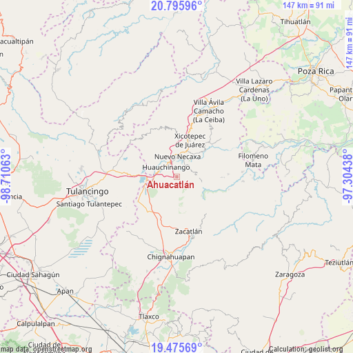
Ahuacatlán GPS coordinates[2]
20° 8' 13.992" North, 98° 0' 27" West
| Map corner | latitude | longitude |
|---|---|---|
| Upper-left | 20.79596°, | -98.71063° |
| Center: | 20.13722°, | -98.0075° |
| Lower-right: | 19.47569°, | -97.30438° |
| Map W x H: | 146.8×146.8 km | = 91.2×91.2mi |
| max Lat: | 32.7° ⇑40.1% North |
| Ahuacatlán: | 20.13722° |
| min Lat: | ⇓59.9% South 14.53588° |
| min Long | Ahuacatlán | max Long |
| -117.105° | -98.0075° | -86.73105° |
| W 63.5%⇐ | ⇒36.5% E |
Elevation
Elevation of Ahuacatlán is 1704 m = 5591 ft, and this is 450.3 m = 1477 ft above average elevation for this country.
| Max E: |
3497 m = 11473 ft | 41.2% |
| Ahuacatlán | 1704 m 5591 ft | |
| Avg. | 1253.7 m = 4113 ft | |
Min E: |
-1 m = -3 ft | 58.8% |
See also: Mexico elevation on elevation.city.
Geographical zone
Ahuacatlán is located in North Torrid zone (between Equator and Tropic of Cancer). Distance of this Northern Tropic circle is 366.9 km =228 mi to North.| Distance of | km | miles | from Ahuacatlán |
|---|---|---|---|
| North Pole | 7768 | 4826.8 | to North |
| Arctic Circle | 5162.1 | 3207.6 | to North |
| Tropic Cancer | 366.9 | 228 | to North |
| Equator | 2239 | 1391.2 | to South |


Nearby cities:
15 places around Ahuacatlán: (largest is in red/bold)
• Chicahuaxtla
6.5 km =4 mi,  84°
84°
• Cuacuila
4.6 km =2.9 mi,  327°
327°
• Cuautlita
6.8 km =4.2 mi,  347°
347°
• Huauchinango
6.4 km =4 mi,  309°
309°
• Ocpaco
3 km =1.9 mi,  288°
288°
• Palzoquitla
4.1 km =2.5 mi,  125°
125°
• Papatlazolco
4.8 km =3 mi,  20°
20°
• San Lorenzo Tlaxipehuala
3.6 km =2.2 mi,  102°
102°
• Tlalmaya
3.3 km =2.1 mi,  45°
45°
• Tlaltenango
5.3 km =3.3 mi,  114°
114°
• Tzahuinco
7.3 km =4.5 mi,  7°
7°
• Xaltepec
3.2 km =2 mi, 11°
• Xaltepuxtla
5.6 km =3.5 mi,  41°
41°
• Xilocuautla
1.7 km =1.1 mi,  278°
278°
• Zempoala
5.7 km =3.5 mi,  170°
170°
Sources, notices
• [Note1] Compared only with cities in Mexico existing in our database
• [Src1] Map data: © OpenStreetMap contributors (CC-BY-SA)
• [Src2] Other city data from geonames.org with taken over terms of usage.
• [Src3] Geographical zone / Annual Mean Temperature by Robert A. Rohde @ Wikipedia
