Zempoala geodata
Zempoala (Puebla) is a populated place; located in Mexico in America/Mexico_City (GMT-6) time zone. With population of 1,550 people, there are 5564 cities with bigger population in this country. Compared to other cities in Mexico, 58.9% of cities are located further ↓South; 63.6% of cities are located further ←West and 51.1% of cities have lower elevation than Zempoala. Note1


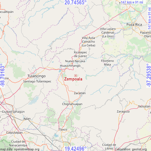
Zempoala GPS coordinates[2]
20° 5' 12.12" North, 97° 59' 54.6" West
| Map corner | latitude | longitude |
|---|---|---|
| Upper-left | 20.74565°, | -98.70163° |
| Center: | 20.0867°, | -97.9985° |
| Lower-right: | 19.42496°, | -97.29538° |
| Map W x H: | 146.8×146.8 km | = 91.2×91.2mi |
| max Lat: | 32.7° ⇑41.1% North |
| Zempoala: | 20.0867° |
| min Lat: | ⇓58.9% South 14.53588° |
| min Long | Zempoala | max Long |
| -117.105° | -97.9985° | -86.73105° |
| W 63.6%⇐ | ⇒36.4% E |
Elevation
Elevation of Zempoala is 1486 m = 4875 ft, and this is 232.3 m = 762 ft above average elevation for this country.
| Max E: |
3497 m = 11473 ft | 48.9% |
| Zempoala | 1486 m 4875 ft | |
| Avg. | 1253.7 m = 4113 ft | |
Min E: |
-1 m = -3 ft | 51.1% |
See also: Mexico elevation on elevation.city.
Geographical zone
Zempoala is located in North Torrid zone (between Equator and Tropic of Cancer). Distance of this Northern Tropic circle is 372.5 km =231.5 mi to North.| Distance of | km | miles | from Zempoala |
|---|---|---|---|
| North Pole | 7773.6 | 4830.3 | to North |
| Arctic Circle | 5167.7 | 3211.1 | to North |
| Tropic Cancer | 372.5 | 231.5 | to North |
| Equator | 2233.4 | 1387.8 | to South |


Nearby cities:
15 places around Zempoala: (largest is in red/bold)
• Ahuacatlán
5.7 km =3.5 mi,  350°
350°
• Camotepec
8.5 km =5.3 mi,  238°
238°
• Chicahuaxtla
8.3 km =5.2 mi,  41°
41°
• Chiconcuautla
6.3 km =3.9 mi,  81°
81°
• Cuetzalingo
8.2 km =5.1 mi,  103°
103°
• Ocpaco
7.6 km =4.7 mi,  329°
329°
• Palzoquitla
4 km =2.5 mi, 36°
• San Lorenzo Tlaxipehuala
5.5 km =3.4 mi,  28°
28°
• Teopancingo
7.5 km =4.7 mi,  276°
276°
• Tepexco
7.7 km =4.8 mi,  146°
146°
• Tlalmaya
8.1 km =5 mi,  10°
10°
• Tlaltenango
5.2 km =3.2 mi,  48°
48°
• Tlaxco (Santiago Tlaxco)
4.9 km =3 mi,  130°
130°
• Toxtla
5.8 km =3.6 mi,  113°
113°
• Xilocuautla
6.4 km =4 mi,  336°
336°
Sources, notices
• [Note1] Compared only with cities in Mexico existing in our database
• [Src1] Map data: © OpenStreetMap contributors (CC-BY-SA)
• [Src2] Other city data from geonames.org with taken over terms of usage.
• [Src3] Geographical zone / Annual Mean Temperature by Robert A. Rohde @ Wikipedia
