El Mirador geodata
El Mirador (Jalisco) is a populated place; located in Mexico in America/Mexico_City (GMT-6) time zone. With population of 708 people, there are 12292 cities with bigger population in this country. Compared to other cities in Mexico, 78.8% of cities are located further ↓South; 85.3% of cities are located further →East and 65.5% of cities have lower elevation than El Mirador. Note1


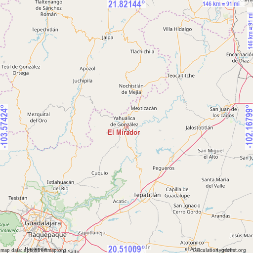
El Mirador GPS coordinates[2]
21° 10' 1.992" North, 102° 52' 15.996" West
| Map corner | latitude | longitude |
|---|---|---|
| Upper-left | 21.82144°, | -103.57424° |
| Center: | 21.16722°, | -102.87111° |
| Lower-right: | 20.51009°, | -102.16799° |
| Map W x H: | 145.8×145.8 km | = 90.6×90.6mi |
| max Lat: | 32.7° ⇑21.2% North |
| El Mirador: | 21.16722° |
| min Lat: | ⇓78.8% South 14.53588° |
| min Long | El Mirador | max Long |
| -117.105° | -102.87111° | -86.73105° |
| W 14.7%⇐ | ⇒85.3% E |
Elevation
Elevation of El Mirador is 1841 m = 6040 ft, and this is 587.3 m = 1927 ft above average elevation for this country.
| Max E: |
3497 m = 11473 ft | 34.5% |
| El Mirador | 1841 m 6040 ft | |
| Avg. | 1253.7 m = 4113 ft | |
Min E: |
-1 m = -3 ft | 65.5% |
See also: Mexico elevation on elevation.city.
Geographical zone
El Mirador is located in North Torrid zone (between Equator and Tropic of Cancer). Distance of this Northern Tropic circle is 252.3 km =156.8 mi to North.| Distance of | km | miles | from El Mirador |
|---|---|---|---|
| North Pole | 7653.5 | 4755.7 | to North |
| Arctic Circle | 5047.6 | 3136.4 | to North |
| Tropic Cancer | 252.3 | 156.8 | to North |
| Equator | 2353.6 | 1462.5 | to South |


Nearby cities:
15 places around El Mirador: (largest is in red/bold)
• Cañadas de Obregón
19.2 km =11.9 mi,  95°
95°
• Colonia Lindavista
23 km =14.3 mi,  2°
2°
• Colonia Lomas del Refugio
22.2 km =13.8 mi,  11°
11°
• Daniel Camarena
20 km =12.4 mi,  353°
353°
• El Zapote
9.1 km =5.7 mi,  131°
131°
• Huisquilco
11.9 km =7.4 mi,  253°
253°
• Juchitlán
23.4 km =14.5 mi,  233°
233°
• Las Cruces
29.8 km =18.5 mi,  237°
237°
• Lázaro Cárdenas
29.2 km =18.1 mi,  212°
212°
• Manalisco
13.1 km =8.1 mi,  203°
203°
• Mexticacán
14.4 km =8.9 mi,  40°
40°
• Mezcala
24 km =14.9 mi,  173°
173°
• Nochistlán de Mejía
22.1 km =13.7 mi, 6°
• San Gabriel
22.2 km =13.8 mi,  221°
221°
• Yahualica de González Gallo
2.1 km =1.3 mi,  311°
311°
Sources, notices
• [Note1] Compared only with cities in Mexico existing in our database
• [Src1] Map data: © OpenStreetMap contributors (CC-BY-SA)
• [Src2] Other city data from geonames.org with taken over terms of usage.
• [Src3] Geographical zone / Annual Mean Temperature by Robert A. Rohde @ Wikipedia
