Juchitlán geodata
Juchitlán (Jalisco) is a populated place; located in Mexico in America/Mexico_City (GMT-6) time zone. With population of 570 people, there are 15008 cities with bigger population in this country. Compared to other cities in Mexico, 77.1% of cities are located further ↓South; 85.9% of cities are located further →East and 69.3% of cities have lower elevation than Juchitlán. Note1


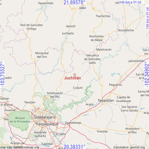
Juchitlán GPS coordinates[2]
21° 2' 27.564" North, 103° 3' 7.704" West
| Map corner | latitude | longitude |
|---|---|---|
| Upper-left | 21.69578°, | -103.75527° |
| Center: | 21.04099°, | -103.05214° |
| Lower-right: | 20.38331°, | -102.34902° |
| Map W x H: | 145.9×145.9 km | = 90.7×90.7mi |
| max Lat: | 32.7° ⇑22.9% North |
| Juchitlán: | 21.04099° |
| min Lat: | ⇓77.1% South 14.53588° |
| min Long | Juchitlán | max Long |
| -117.105° | -103.05214° | -86.73105° |
| W 14.1%⇐ | ⇒85.9% E |
Elevation
Elevation of Juchitlán is 1913 m = 6276 ft, and this is 659.3 m = 2163 ft above average elevation for this country.
| Max E: |
3497 m = 11473 ft | 30.7% |
| Juchitlán | 1913 m 6276 ft | |
| Avg. | 1253.7 m = 4113 ft | |
Min E: |
-1 m = -3 ft | 69.3% |
See also: Mexico elevation on elevation.city.
Geographical zone
Juchitlán is located in North Torrid zone (between Equator and Tropic of Cancer). Distance of this Northern Tropic circle is 266.4 km =165.5 mi to North.| Distance of | km | miles | from Juchitlán |
|---|---|---|---|
| North Pole | 7667.5 | 4764.4 | to North |
| Arctic Circle | 5061.6 | 3145.1 | to North |
| Tropic Cancer | 266.4 | 165.5 | to North |
| Equator | 2339.5 | 1453.7 | to South |


Nearby cities:
15 places around Juchitlán: (largest is in red/bold)
• Cuquío
12.6 km =7.8 mi,  168°
168°
• El Mirador
23.4 km =14.5 mi,  53°
53°
• El Zapote
26.8 km =16.7 mi,  72°
72°
• Huisquilco
12.9 km =8 mi,  34°
34°
• La Esperanza
18.5 km =11.5 mi, 170°
• Las Cruces
6.6 km =4.1 mi,  252°
252°
• Lázaro Cárdenas
11.1 km =6.9 mi,  163°
163°
• Manalisco
13.7 km =8.5 mi,  81°
81°
• Mezcala
23.5 km =14.6 mi,  114°
114°
• Palos Altos
21.6 km =13.4 mi,  209°
209°
• San Antonio de los Vázquez
26.7 km =16.6 mi,  201°
201°
• San Gabriel
4.6 km =2.9 mi,  122°
122°
• San Juan del Monte
15.8 km =9.8 mi, 209°
• Teponahuasco
14.7 km =9.1 mi, 174°
• Yahualica de González Gallo
23.1 km =14.4 mi, 48°
Sources, notices
• [Note1] Compared only with cities in Mexico existing in our database
• [Src1] Map data: © OpenStreetMap contributors (CC-BY-SA)
• [Src2] Other city data from geonames.org with taken over terms of usage.
• [Src3] Geographical zone / Annual Mean Temperature by Robert A. Rohde @ Wikipedia
