El Zapote geodata
El Zapote (Jalisco) is a populated place; located in Mexico in America/Mexico_City (GMT-6) time zone. With population of 4,401 people, there are 2085 cities with bigger population in this country. Compared to other cities in Mexico, 78.1% of cities are located further ↓South; 85.2% of cities are located further →East and 59.2% of cities have lower elevation than El Zapote. Note1


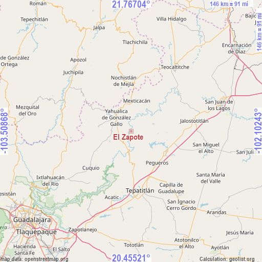
El Zapote GPS coordinates[2]
21° 6' 45.252" North, 102° 48' 19.98" West
| Map corner | latitude | longitude |
|---|---|---|
| Upper-left | 21.76704°, | -103.50868° |
| Center: | 21.11257°, | -102.80555° |
| Lower-right: | 20.45521°, | -102.10243° |
| Map W x H: | 145.9×145.9 km | = 90.7×90.7mi |
| max Lat: | 32.7° ⇑21.9% North |
| El Zapote: | 21.11257° |
| min Lat: | ⇓78.1% South 14.53588° |
| min Long | El Zapote | max Long |
| -117.105° | -102.80555° | -86.73105° |
| W 14.8%⇐ | ⇒85.2% E |
Elevation
Elevation of El Zapote is 1713 m = 5620 ft, and this is 459.3 m = 1507 ft above average elevation for this country.
| Max E: |
3497 m = 11473 ft | 40.8% |
| El Zapote | 1713 m 5620 ft | |
| Avg. | 1253.7 m = 4113 ft | |
Min E: |
-1 m = -3 ft | 59.2% |
See also: Mexico elevation on elevation.city.
Geographical zone
El Zapote is located in North Torrid zone (between Equator and Tropic of Cancer). Distance of this Northern Tropic circle is 258.4 km =160.6 mi to North.| Distance of | km | miles | from El Zapote |
|---|---|---|---|
| North Pole | 7659.6 | 4759.5 | to North |
| Arctic Circle | 5053.7 | 3140.2 | to North |
| Tropic Cancer | 258.4 | 160.6 | to North |
| Equator | 2347.5 | 1458.7 | to South |


Nearby cities:
15 places around El Zapote: (largest is in red/bold)
• Cañadas de Obregón
12.9 km =8 mi,  71°
71°
• Colonia Lomas del Refugio
27.9 km =17.3 mi,  355°
355°
• Daniel Camarena
27.5 km =17.1 mi,  340°
340°
• El Mirador
9.1 km =5.7 mi,  311°
311°
• Huisquilco
18.4 km =11.4 mi,  278°
278°
• Juchitlán
26.8 km =16.7 mi,  252°
252°
• Lázaro Cárdenas
29.2 km =18.1 mi,  230°
230°
• Manalisco
13.5 km =8.4 mi,  243°
243°
• Mexticacán
17.2 km =10.7 mi,  8°
8°
• Mezcala
18.3 km =11.4 mi,  193°
193°
• Nochistlán de Mejía
28.3 km =17.6 mi,  351°
351°
• Pegueros
22.8 km =14.2 mi,  141°
141°
• San Gabriel
24 km =14.9 mi, 244°
• Valle de Guadalupe
22.6 km =14 mi,  119°
119°
• Yahualica de González Gallo
11.2 km =7 mi, 311°
Sources, notices
• [Note1] Compared only with cities in Mexico existing in our database
• [Src1] Map data: © OpenStreetMap contributors (CC-BY-SA)
• [Src2] Other city data from geonames.org with taken over terms of usage.
• [Src3] Geographical zone / Annual Mean Temperature by Robert A. Rohde @ Wikipedia
