San Gabriel geodata
San Gabriel (Jalisco) is a populated place; located in Mexico in America/Mexico_City (GMT-6) time zone. With population of 4,358 people, there are 2103 cities with bigger population in this country. Compared to other cities in Mexico, 76.7% of cities are located further ↓South; 85.8% of cities are located further →East and 68.1% of cities have lower elevation than San Gabriel. Note1


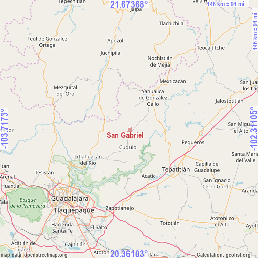
San Gabriel GPS coordinates[2]
21° 1' 7.68" North, 103° 0' 51.012" West
| Map corner | latitude | longitude |
|---|---|---|
| Upper-left | 21.67368°, | -103.7173° |
| Center: | 21.0188°, | -103.01417° |
| Lower-right: | 20.36103°, | -102.31105° |
| Map W x H: | 146×146 km | = 90.7×90.7mi |
| max Lat: | 32.7° ⇑23.3% North |
| San Gabriel: | 21.0188° |
| min Lat: | ⇓76.7% South 14.53588° |
| min Long | San Gabriel | max Long |
| -117.105° | -103.01417° | -86.73105° |
| W 14.2%⇐ | ⇒85.8% E |
Elevation
Elevation of San Gabriel is 1892 m = 6207 ft, and this is 638.3 m = 2094 ft above average elevation for this country.
| Max E: |
3497 m = 11473 ft | 31.9% |
| San Gabriel | 1892 m 6207 ft | |
| Avg. | 1253.7 m = 4113 ft | |
Min E: |
-1 m = -3 ft | 68.1% |
See also: Mexico elevation on elevation.city.
Geographical zone
San Gabriel is located in North Torrid zone (between Equator and Tropic of Cancer). Distance of this Northern Tropic circle is 268.8 km =167 mi to North.| Distance of | km | miles | from San Gabriel |
|---|---|---|---|
| North Pole | 7670 | 4765.9 | to North |
| Arctic Circle | 5064.1 | 3146.7 | to North |
| Tropic Cancer | 268.8 | 167 | to North |
| Equator | 2337.1 | 1452.2 | to South |


Nearby cities:
15 places around San Gabriel: (largest is in red/bold)
• Cuquío
9.9 km =6.2 mi,  188°
188°
• El Mirador
22.2 km =13.8 mi,  41°
41°
• El Zapote
24 km =14.9 mi,  64°
64°
• Huisquilco
13.5 km =8.4 mi,  14°
14°
• Juchitlán
4.6 km =2.9 mi,  302°
302°
• La Esperanza
15.8 km =9.8 mi,  183°
183°
• Las Cruces
10.3 km =6.4 mi,  272°
272°
• Lázaro Cárdenas
8.2 km =5.1 mi, 185°
• Manalisco
10.6 km =6.6 mi, 64°
• Mezcala
18.9 km =11.7 mi,  112°
112°
• Palos Altos
21.8 km =13.5 mi,  221°
221°
• San Antonio de los Vázquez
26.2 km =16.3 mi,  211°
211°
• San Juan del Monte
16.3 km =10.1 mi,  225°
225°
• Teponahuasco
12.5 km =7.8 mi, 192°
• Yahualica de González Gallo
22.3 km =13.9 mi, 36°
Sources, notices
• [Note1] Compared only with cities in Mexico existing in our database
• [Src1] Map data: © OpenStreetMap contributors (CC-BY-SA)
• [Src2] Other city data from geonames.org with taken over terms of usage.
• [Src3] Geographical zone / Annual Mean Temperature by Robert A. Rohde @ Wikipedia
