Huacaltzingo geodata
Huacaltzingo (Puebla) is a populated place; located in Mexico in America/Mexico_City (GMT-6) time zone. With population of 693 people, there are 12564 cities with bigger population in this country. Compared to other cities in Mexico, 68.7% of cities are located further ↑North; 65.3% of cities are located further ←West and 72.5% of cities have lower elevation than Huacaltzingo. Note1


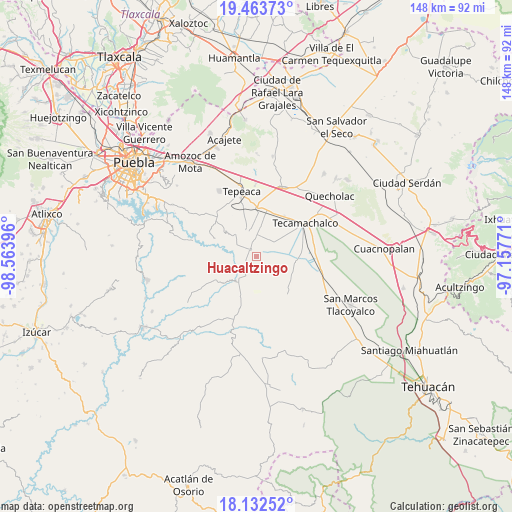
Huacaltzingo GPS coordinates[2]
18° 47' 57.984" North, 97° 51' 38.988" West
| Map corner | latitude | longitude |
|---|---|---|
| Upper-left | 19.46373°, | -98.56396° |
| Center: | 18.79944°, | -97.86083° |
| Lower-right: | 18.13252°, | -97.15771° |
| Map W x H: | 148×148 km | = 92×92mi |
| max Lat: | 32.7° ⇑68.7% North |
| Huacaltzingo: | 18.79944° |
| min Lat: | ⇓31.3% South 14.53588° |
| min Long | Huacaltzingo | max Long |
| -117.105° | -97.86083° | -86.73105° |
| W 65.3%⇐ | ⇒34.7% E |
Elevation
Elevation of Huacaltzingo is 1977 m = 6486 ft, and this is 723.3 m = 2373 ft above average elevation for this country.
| Max E: |
3497 m = 11473 ft | 27.5% |
| Huacaltzingo | 1977 m 6486 ft | |
| Avg. | 1253.7 m = 4113 ft | |
Min E: |
-1 m = -3 ft | 72.5% |
See also: Mexico elevation on elevation.city.
Geographical zone
Huacaltzingo is located in North Torrid zone (between Equator and Tropic of Cancer). Distance of this Northern Tropic circle is 515.6 km =320.4 mi to North.| Distance of | km | miles | from Huacaltzingo |
|---|---|---|---|
| North Pole | 7916.8 | 4919.3 | to North |
| Arctic Circle | 5310.9 | 3300 | to North |
| Tropic Cancer | 515.6 | 320.4 | to North |
| Equator | 2090.3 | 1298.9 | to South |


Nearby cities:
15 places around Huacaltzingo: (largest is in red/bold)
• Ahuatepec
8.9 km =5.5 mi,  317°
317°
• Atoyatempan
6 km =3.7 mi,  291°
291°
• Chipiltepec
9.8 km =6.1 mi,  12°
12°
• Dolores Hidalgo
4.7 km =2.9 mi,  179°
179°
• La Purísima
7.7 km =4.8 mi,  64°
64°
• La Soledad
10.2 km =6.3 mi,  83°
83°
• Ometepec
6.2 km =3.9 mi, 7°
• Santa Ana Coapan
4.8 km =3 mi, 317°
• Santa Clara Huitziltepec
4 km =2.5 mi,  212°
212°
• Santa Cruz Huitziltepec
7.5 km =4.7 mi,  192°
192°
• Tepeyahualco
2.4 km =1.5 mi,  314°
314°
• Tlanepantla
7.6 km =4.7 mi,  338°
338°
• Tochtepec
6 km =3.7 mi,  42°
42°
• Veracrucito
9 km =5.6 mi,  49°
49°
• Zacaola
9.2 km =5.7 mi, 8°
Sources, notices
• [Note1] Compared only with cities in Mexico existing in our database
• [Src1] Map data: © OpenStreetMap contributors (CC-BY-SA)
• [Src2] Other city data from geonames.org with taken over terms of usage.
• [Src3] Geographical zone / Annual Mean Temperature by Robert A. Rohde @ Wikipedia
