Tlanepantla geodata
Tlanepantla (Puebla) is a seat of a second-order administrative division; located in Mexico in America/Mexico_City (GMT-6) time zone. With population of 4,707 people, there are 1963 cities with bigger population in this country. Compared to other cities in Mexico, 67.8% of cities are located further ↑North; 65% of cities are located further ←West and 73.7% of cities have lower elevation than Tlanepantla. Note1


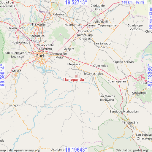
Tlanepantla GPS coordinates[2]
18° 51' 47.16" North, 97° 53' 13.236" West
| Map corner | latitude | longitude |
|---|---|---|
| Upper-left | 19.52713°, | -98.59014° |
| Center: | 18.8631°, | -97.88701° |
| Lower-right: | 18.19643°, | -97.18389° |
| Map W x H: | 148×148 km | = 92×92mi |
| max Lat: | 32.7° ⇑67.8% North |
| Tlanepantla: | 18.8631° |
| min Lat: | ⇓32.2% South 14.53588° |
| min Long | Tlanepantla | max Long |
| -117.105° | -97.88701° | -86.73105° |
| W 65%⇐ | ⇒35% E |
Elevation
Elevation of Tlanepantla is 2004 m = 6575 ft, and this is 750.3 m = 2462 ft above average elevation for this country.
| Max E: |
3497 m = 11473 ft | 26.3% |
| Tlanepantla | 2004 m 6575 ft | |
| Avg. | 1253.7 m = 4113 ft | |
Min E: |
-1 m = -3 ft | 73.7% |
See also: Mexico elevation on elevation.city.
Geographical zone
Tlanepantla is located in North Torrid zone (between Equator and Tropic of Cancer). Distance of this Northern Tropic circle is 508.5 km =316 mi to North.| Distance of | km | miles | from Tlanepantla |
|---|---|---|---|
| North Pole | 7909.7 | 4914.9 | to North |
| Arctic Circle | 5303.8 | 3295.6 | to North |
| Tropic Cancer | 508.5 | 316 | to North |
| Equator | 2097.4 | 1303.3 | to South |


Nearby cities:
15 places around Tlanepantla: (largest is in red/bold)
• Ahuatepec
3.3 km =2.1 mi,  260°
260°
• Atoyatempan
5.6 km =3.5 mi,  210°
210°
• Chipiltepec
5.5 km =3.4 mi,  62°
62°
• Huacaltzingo
7.6 km =4.7 mi,  158°
158°
• Hueyotlipan
3.9 km =2.4 mi,  35°
35°
• Mixtla
4.7 km =2.9 mi,  349°
349°
• Ometepec
3.7 km =2.3 mi,  105°
105°
• San Buenaventura
6 km =3.7 mi,  316°
316°
• San Martín Caltenco
7.6 km =4.7 mi,  71°
71°
• San Nicolás Zoyapetlayoca
7.2 km =4.5 mi,  18°
18°
• San Simón Coatepec
5.8 km =3.6 mi,  357°
357°
• Santa Ana Coapan
3.6 km =2.2 mi,  187°
187°
• Tepeyahualco
5.5 km =3.4 mi,  169°
169°
• Tochtepec
7.3 km =4.5 mi, 111°
• Zacaola
4.6 km =2.9 mi, 64°
Sources, notices
• [Note1] Compared only with cities in Mexico existing in our database
• [Src1] Map data: © OpenStreetMap contributors (CC-BY-SA)
• [Src2] Other city data from geonames.org with taken over terms of usage.
• [Src3] Geographical zone / Annual Mean Temperature by Robert A. Rohde @ Wikipedia
