Alto de Ventura geodata
Alto de Ventura (Guerrero) is a populated place; located in Mexico in America/Mexico_City (GMT-6) time zone. With population of 667 people, there are 13011 cities with bigger population in this country. Compared to other cities in Mexico, 92.7% of cities are located further ↑North; 53.7% of cities are located further →East and 89% of cities have higher elevation than Alto de Ventura. Note1


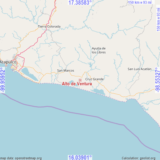
Alto de Ventura GPS coordinates[2]
16° 42' 48.996" North, 99° 15' 23.004" West
| Map corner | latitude | longitude |
|---|---|---|
| Upper-left | 17.38583°, | -99.95952° |
| Center: | 16.71361°, | -99.25639° |
| Lower-right: | 16.03901°, | -98.55327° |
| Map W x H: | 149.8×149.8 km | = 93.1×93.1mi |
| max Lat: | 32.7° ⇑92.7% North |
| Alto de Ventura: | 16.71361° |
| min Lat: | ⇓7.3% South 14.53588° |
| min Long | Alto de Ventura | max Long |
| -117.105° | -99.25639° | -86.73105° |
| W 46.3%⇐ | ⇒53.7% E |
Elevation
Elevation of Alto de Ventura is 27 m = 89 ft, and this is 1226.7 m = 4025 ft below average elevation for this country.
| Max E: |
3497 m = 11473 ft | 89% |
| Avg. | 1253.7 m = 4113 ft | |
| Alto de Ventura | 27 m = 89 ft | |
Min E: |
-1 m = -3 ft | 11% |
See also: Mexico elevation on elevation.city.
Geographical zone
Alto de Ventura is located in North Torrid zone (between Equator and Tropic of Cancer). Distance of this Northern Tropic circle is 747.5 km =464.5 mi to North.| Distance of | km | miles | from Alto de Ventura |
|---|---|---|---|
| North Pole | 8148.7 | 5063.4 | to North |
| Arctic Circle | 5542.8 | 3444.1 | to North |
| Tropic Cancer | 747.5 | 464.5 | to North |
| Equator | 1858.4 | 1154.8 | to South |


Nearby cities:
15 places around Alto de Ventura: (largest is in red/bold)
• Arroyo de Limón
9.8 km =6.1 mi,  0°
0°
• Cruz Grande
14.2 km =8.8 mi,  86°
86°
• Cuatro Bancos
9.4 km =5.8 mi,  116°
116°
• El Porvenir
9.5 km =5.9 mi,  43°
43°
• Estero Verde
5.6 km =3.5 mi,  138°
138°
• La Unión
18.3 km =11.4 mi,  49°
49°
• Las Animas
8.4 km =5.2 mi, 135°
• Las Vigas
6 km =3.7 mi,  28°
28°
• Llano Grande
9.1 km =5.7 mi,  73°
73°
• Pico del Monte
18.4 km =11.4 mi,  128°
128°
• Rancho Viejo
17.2 km =10.7 mi,  348°
348°
• San Marcos
17 km =10.6 mi,  303°
303°
• Santa Elena Guerrero
19 km =11.8 mi,  334°
334°
• Santa Elena de la Villa
19 km =11.8 mi,  338°
338°
• Tecomate Pesquería
11.7 km =7.3 mi,  260°
260°
Sources, notices
• [Note1] Compared only with cities in Mexico existing in our database
• [Src1] Map data: © OpenStreetMap contributors (CC-BY-SA)
• [Src2] Other city data from geonames.org with taken over terms of usage.
• [Src3] Geographical zone / Annual Mean Temperature by Robert A. Rohde @ Wikipedia
