El Porvenir geodata
El Porvenir (Guerrero) is a populated place; located in Mexico in America/Mexico_City (GMT-6) time zone. With population of 564 people, there are 15153 cities with bigger population in this country. Compared to other cities in Mexico, 92% of cities are located further ↑North; 52.7% of cities are located further →East and 86.3% of cities have higher elevation than El Porvenir. Note1


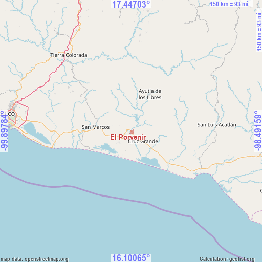
El Porvenir GPS coordinates[2]
16° 46' 30.108" North, 99° 11' 40.956" West
| Map corner | latitude | longitude |
|---|---|---|
| Upper-left | 17.44703°, | -99.89784° |
| Center: | 16.77503°, | -99.19471° |
| Lower-right: | 16.10065°, | -98.49159° |
| Map W x H: | 149.7×149.7 km | = 93×93mi |
| max Lat: | 32.7° ⇑92% North |
| El Porvenir: | 16.77503° |
| min Lat: | ⇓8% South 14.53588° |
| min Long | El Porvenir | max Long |
| -117.105° | -99.19471° | -86.73105° |
| W 47.3%⇐ | ⇒52.7% E |
Elevation
Elevation of El Porvenir is 37 m = 121 ft, and this is 1216.7 m = 3992 ft below average elevation for this country.
| Max E: |
3497 m = 11473 ft | 86.3% |
| Avg. | 1253.7 m = 4113 ft | |
| El Porvenir | 37 m = 121 ft | |
Min E: |
-1 m = -3 ft | 13.7% |
See also: Mexico elevation on elevation.city.
Geographical zone
El Porvenir is located in North Torrid zone (between Equator and Tropic of Cancer). Distance of this Northern Tropic circle is 740.7 km =460.2 mi to North.| Distance of | km | miles | from El Porvenir |
|---|---|---|---|
| North Pole | 8141.9 | 5059.1 | to North |
| Arctic Circle | 5536 | 3439.9 | to North |
| Tropic Cancer | 740.7 | 460.2 | to North |
| Equator | 1865.2 | 1159 | to South |


Nearby cities:
15 places around El Porvenir: (largest is in red/bold)
• Alto de Ventura
9.5 km =5.9 mi,  223°
223°
• Arroyo de Limón
7.2 km =4.5 mi,  294°
294°
• Cruz Grande
9.6 km =6 mi,  127°
127°
• Cuatro Bancos
11.1 km =6.9 mi,  170°
170°
• El Mesón
16.5 km =10.3 mi,  61°
61°
• El Tecorral
16.4 km =10.2 mi,  330°
330°
• El Zapote
12.8 km =8 mi, 58°
• Estero Verde
11.4 km =7.1 mi,  194°
194°
• Jalapa
16.4 km =10.2 mi,  115°
115°
• La Unión
9 km =5.6 mi, 55°
• Las Animas
12.9 km =8 mi,  183°
183°
• Las Vigas
4 km =2.5 mi,  247°
247°
• Llano Grande
4.7 km =2.9 mi,  152°
152°
• Pozolapa
15 km =9.3 mi,  40°
40°
• Rancho Viejo
14.2 km =8.8 mi,  314°
314°
Sources, notices
• [Note1] Compared only with cities in Mexico existing in our database
• [Src1] Map data: © OpenStreetMap contributors (CC-BY-SA)
• [Src2] Other city data from geonames.org with taken over terms of usage.
• [Src3] Geographical zone / Annual Mean Temperature by Robert A. Rohde @ Wikipedia
