Las Vigas geodata
Las Vigas (Guerrero) is a populated place; located in Mexico in America/Mexico_City (GMT-6) time zone. With population of 4,504 people, there are 2042 cities with bigger population in this country. Compared to other cities in Mexico, 92.2% of cities are located further ↑North; 53.3% of cities are located further →East and 87% of cities have higher elevation than Las Vigas. Note1


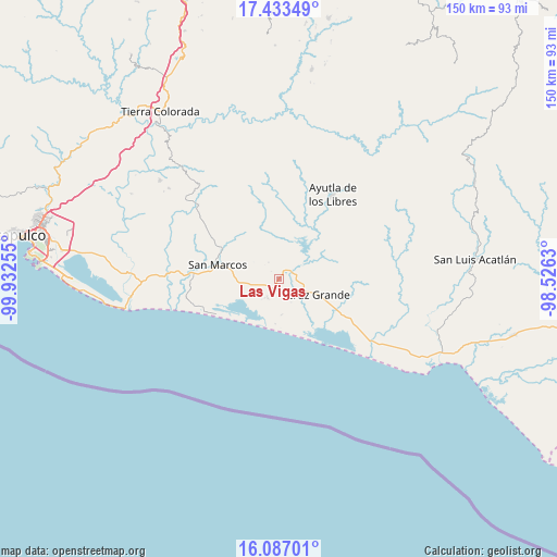
Las Vigas GPS coordinates[2]
16° 45' 41.184" North, 99° 13' 45.912" West
| Map corner | latitude | longitude |
|---|---|---|
| Upper-left | 17.43349°, | -99.93255° |
| Center: | 16.76144°, | -99.22942° |
| Lower-right: | 16.08701°, | -98.5263° |
| Map W x H: | 149.7×149.7 km | = 93×93mi |
| max Lat: | 32.7° ⇑92.2% North |
| Las Vigas: | 16.76144° |
| min Lat: | ⇓7.8% South 14.53588° |
| min Long | Las Vigas | max Long |
| -117.105° | -99.22942° | -86.73105° |
| W 46.7%⇐ | ⇒53.3% E |
Elevation
Elevation of Las Vigas is 34 m = 112 ft, and this is 1219.7 m = 4002 ft below average elevation for this country.
| Max E: |
3497 m = 11473 ft | 87% |
| Avg. | 1253.7 m = 4113 ft | |
| Las Vigas | 34 m = 112 ft | |
Min E: |
-1 m = -3 ft | 13% |
See also: Mexico elevation on elevation.city.
Geographical zone
Las Vigas is located in North Torrid zone (between Equator and Tropic of Cancer). Distance of this Northern Tropic circle is 742.2 km =461.2 mi to North.| Distance of | km | miles | from Las Vigas |
|---|---|---|---|
| North Pole | 8143.4 | 5060.1 | to North |
| Arctic Circle | 5537.5 | 3440.8 | to North |
| Tropic Cancer | 742.2 | 461.2 | to North |
| Equator | 1863.7 | 1158 | to South |


Nearby cities:
15 places around Las Vigas: (largest is in red/bold)
• Alto de Ventura
6 km =3.7 mi,  208°
208°
• Arroyo de Limón
5.3 km =3.3 mi,  327°
327°
• Cruz Grande
12.1 km =7.5 mi,  111°
111°
• Cuatro Bancos
10.9 km =6.8 mi,  149°
149°
• El Amatal
15.6 km =9.7 mi, 325°
• El Porvenir
4 km =2.5 mi,  67°
67°
• El Tecorral
16.3 km =10.1 mi,  344°
344°
• Estero Verde
9.5 km =5.9 mi,  174°
174°
• La Unión
12.9 km =8 mi,  59°
59°
• Las Animas
11.7 km =7.3 mi, 165°
• Llano Grande
6.4 km =4 mi, 114°
• Rancho Viejo
13.2 km =8.2 mi, 330°
• Santa Elena Guerrero
16.2 km =10.1 mi,  316°
316°
• Santa Elena de la Villa
15.8 km =9.8 mi, 321°
• Tecomate Pesquería
16.1 km =10 mi,  243°
243°
Sources, notices
• [Note1] Compared only with cities in Mexico existing in our database
• [Src1] Map data: © OpenStreetMap contributors (CC-BY-SA)
• [Src2] Other city data from geonames.org with taken over terms of usage.
• [Src3] Geographical zone / Annual Mean Temperature by Robert A. Rohde @ Wikipedia
