Cruz Grande geodata
Cruz Grande (Guerrero) is a seat of a second-order administrative division; located in Mexico in America/Mexico_City (GMT-6) time zone. With population of 11,783 people, there are 816 cities with bigger population in this country. Compared to other cities in Mexico, 92.6% of cities are located further ↑North; 51.5% of cities are located further →East and 83.9% of cities have higher elevation than Cruz Grande. Note1


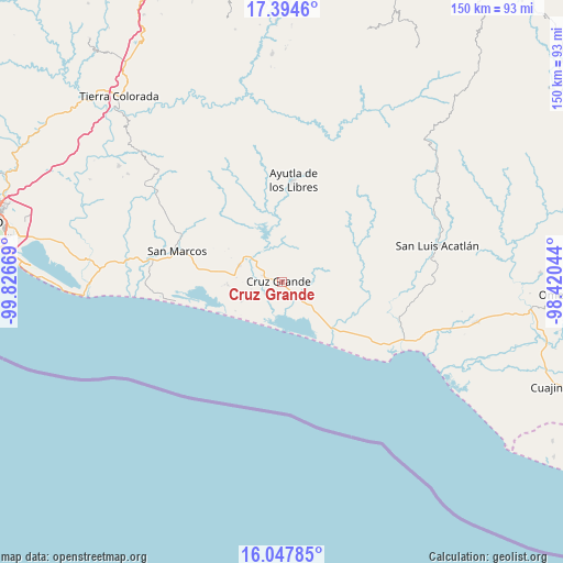
Cruz Grande GPS coordinates[2]
16° 43' 20.676" North, 99° 7' 24.816" West
| Map corner | latitude | longitude |
|---|---|---|
| Upper-left | 17.3946°, | -99.82669° |
| Center: | 16.72241°, | -99.12356° |
| Lower-right: | 16.04785°, | -98.42044° |
| Map W x H: | 149.7×149.7 km | = 93×93mi |
| max Lat: | 32.7° ⇑92.6% North |
| Cruz Grande: | 16.72241° |
| min Lat: | ⇓7.4% South 14.53588° |
| min Long | Cruz Grande | max Long |
| -117.105° | -99.12356° | -86.73105° |
| W 48.5%⇐ | ⇒51.5% E |
Elevation
Elevation of Cruz Grande is 52 m = 171 ft, and this is 1201.7 m = 3943 ft below average elevation for this country.
| Max E: |
3497 m = 11473 ft | 83.9% |
| Avg. | 1253.7 m = 4113 ft | |
| Cruz Grande | 52 m = 171 ft | |
Min E: |
-1 m = -3 ft | 16.1% |
See also: Mexico elevation on elevation.city.
Geographical zone
Cruz Grande is located in North Torrid zone (between Equator and Tropic of Cancer). Distance of this Northern Tropic circle is 746.6 km =463.9 mi to North.| Distance of | km | miles | from Cruz Grande |
|---|---|---|---|
| North Pole | 8147.7 | 5062.7 | to North |
| Arctic Circle | 5541.8 | 3443.5 | to North |
| Tropic Cancer | 746.6 | 463.9 | to North |
| Equator | 1859.4 | 1155.4 | to South |


Nearby cities:
15 places around Cruz Grande: (largest is in red/bold)
• Chautengo
9.5 km =5.9 mi,  159°
159°
• Cuatro Bancos
7.7 km =4.8 mi,  228°
228°
• Cuautepec
13.3 km =8.3 mi,  76°
76°
• El Pabellón
12.5 km =7.8 mi,  113°
113°
• El Porvenir
9.6 km =6 mi,  307°
307°
• El Zapote
13 km =8.1 mi,  14°
14°
• Estero Verde
11.6 km =7.2 mi,  243°
243°
• Jalapa
7.3 km =4.5 mi,  98°
98°
• La Dicha
13 km =8.1 mi,  67°
67°
• La Unión
10.9 km =6.8 mi,  359°
359°
• Las Animas
10.8 km =6.7 mi, 229°
• Las Peñas
12 km =7.5 mi,  145°
145°
• Las Vigas
12.1 km =7.5 mi,  291°
291°
• Llano Grande
5.7 km =3.5 mi, 286°
• Pico del Monte
12.5 km =7.8 mi,  179°
179°
Sources, notices
• [Note1] Compared only with cities in Mexico existing in our database
• [Src1] Map data: © OpenStreetMap contributors (CC-BY-SA)
• [Src2] Other city data from geonames.org with taken over terms of usage.
• [Src3] Geographical zone / Annual Mean Temperature by Robert A. Rohde @ Wikipedia
