Monte Alegre geodata
Monte Alegre (Guerrero) is a populated place; located in Mexico in America/Mexico_City (GMT-6) time zone. With population of 610 people, there are 14138 cities with bigger population in this country. Compared to other cities in Mexico, 83.2% of cities are located further ↑North; 54.2% of cities are located further →East and 54.2% of cities have lower elevation than Monte Alegre. Note1


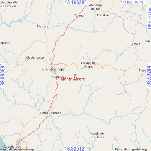
Monte Alegre GPS coordinates[2]
17° 29' 48.984" North, 99° 17' 44.016" West
| Map corner | latitude | longitude |
|---|---|---|
| Upper-left | 18.16628°, | -99.99869° |
| Center: | 17.49694°, | -99.29556° |
| Lower-right: | 16.82512°, | -98.59244° |
| Map W x H: | 149.1×149.1 km | = 92.6×92.6mi |
| max Lat: | 32.7° ⇑83.2% North |
| Monte Alegre: | 17.49694° |
| min Lat: | ⇓16.8% South 14.53588° |
| min Long | Monte Alegre | max Long |
| -117.105° | -99.29556° | -86.73105° |
| W 45.8%⇐ | ⇒54.2% E |
Elevation
Elevation of Monte Alegre is 1566 m = 5138 ft, and this is 312.3 m = 1025 ft above average elevation for this country.
| Max E: |
3497 m = 11473 ft | 45.8% |
| Monte Alegre | 1566 m 5138 ft | |
| Avg. | 1253.7 m = 4113 ft | |
Min E: |
-1 m = -3 ft | 54.2% |
See also: Mexico elevation on elevation.city.
Geographical zone
Monte Alegre is located in North Torrid zone (between Equator and Tropic of Cancer). Distance of this Northern Tropic circle is 660.4 km =410.4 mi to North.| Distance of | km | miles | from Monte Alegre |
|---|---|---|---|
| North Pole | 8061.6 | 5009.2 | to North |
| Arctic Circle | 5455.7 | 3390 | to North |
| Tropic Cancer | 660.4 | 410.4 | to North |
| Equator | 1945.5 | 1208.9 | to South |


Nearby cities:
15 places around Monte Alegre: (largest is in red/bold)
• Achigca
6.8 km =4.2 mi,  111°
111°
• Acuentla
5.5 km =3.4 mi,  64°
64°
• Ahuexotitlán
6.5 km =4 mi, 57°
• Chilacachapa
6.9 km =4.3 mi,  15°
15°
• Coatomatitlán
4.1 km =2.5 mi,  227°
227°
• Cuonetzingo
4.6 km =2.9 mi,  43°
43°
• El Durazno
3.5 km =2.2 mi,  8°
8°
• Mochitlán
8.4 km =5.2 mi,  250°
250°
• Popoyatlajco
2.8 km =1.7 mi,  81°
81°
• San Martín
3.8 km =2.4 mi,  178°
178°
• San Miguel
3.7 km =2.3 mi,  190°
190°
• Tlamixtlahuacan
7.4 km =4.6 mi, 84°
• Tonalapa
5.7 km =3.5 mi,  97°
97°
• Zacatzonapa
5.1 km =3.2 mi,  276°
276°
• Zoquiapa
5.7 km =3.5 mi, 20°
Sources, notices
• [Note1] Compared only with cities in Mexico existing in our database
• [Src1] Map data: © OpenStreetMap contributors (CC-BY-SA)
• [Src2] Other city data from geonames.org with taken over terms of usage.
• [Src3] Geographical zone / Annual Mean Temperature by Robert A. Rohde @ Wikipedia
