San Miguel geodata
San Miguel (Guerrero) is a populated place; located in Mexico in America/Mexico_City (GMT-6) time zone. With population of 905 people, there are 9644 cities with bigger population in this country. Compared to other cities in Mexico, 83.5% of cities are located further ↑North; 54.2% of cities are located further →East and 60.4% of cities have higher elevation than San Miguel. Note1


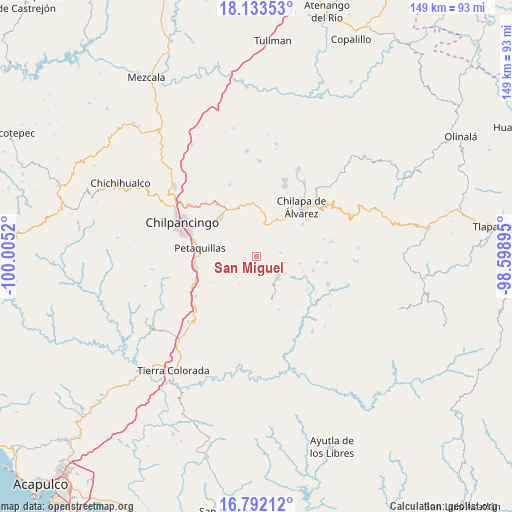
San Miguel GPS coordinates[2]
17° 27' 50.616" North, 99° 18' 7.452" West
| Map corner | latitude | longitude |
|---|---|---|
| Upper-left | 18.13353°, | -100.0052° |
| Center: | 17.46406°, | -99.30207° |
| Lower-right: | 16.79212°, | -98.59895° |
| Map W x H: | 149.2×149.2 km | = 92.7×92.7mi |
| max Lat: | 32.7° ⇑83.5% North |
| San Miguel: | 17.46406° |
| min Lat: | ⇓16.5% South 14.53588° |
| min Long | San Miguel | max Long |
| -117.105° | -99.30207° | -86.73105° |
| W 45.8%⇐ | ⇒54.2% E |
Elevation
Elevation of San Miguel is 974 m = 3196 ft, and this is 279.7 m = 918 ft below average elevation for this country.
| Max E: |
3497 m = 11473 ft | 60.4% |
| Avg. | 1253.7 m = 4113 ft | |
| San Miguel | 974 m = 3196 ft | |
Min E: |
-1 m = -3 ft | 39.6% |
See also: Mexico elevation on elevation.city.
Geographical zone
San Miguel is located in North Torrid zone (between Equator and Tropic of Cancer). Distance of this Northern Tropic circle is 664.1 km =412.7 mi to North.| Distance of | km | miles | from San Miguel |
|---|---|---|---|
| North Pole | 8065.2 | 5011.5 | to North |
| Arctic Circle | 5459.4 | 3392.3 | to North |
| Tropic Cancer | 664.1 | 412.7 | to North |
| Equator | 1941.8 | 1206.6 | to South |


Nearby cities:
15 places around San Miguel: (largest is in red/bold)
• Achigca
7.2 km =4.5 mi,  80°
80°
• Acuentla
8.3 km =5.2 mi,  42°
42°
• Coatomatitlán
2.5 km =1.6 mi,  290°
290°
• Coaxtlahuacán
9.3 km =5.8 mi,  211°
211°
• Cuonetzingo
8 km =5 mi,  28°
28°
• El Durazno
7.2 km =4.5 mi,  9°
9°
• Mochitlán
7.3 km =4.5 mi,  276°
276°
• Monte Alegre
3.7 km =2.3 mi, 10°
• Ostocapa
8.5 km =5.3 mi,  102°
102°
• Popoyatlajco
5.3 km =3.3 mi, 40°
• Quechultenango
8.4 km =5.2 mi,  131°
131°
• San Martín
0.8 km =0.5 mi, 97°
• Tlamixtlahuacan
9.2 km =5.7 mi,  61°
61°
• Tonalapa
7 km =4.3 mi,  65°
65°
• Zacatzonapa
6.1 km =3.8 mi,  314°
314°
Sources, notices
• [Note1] Compared only with cities in Mexico existing in our database
• [Src1] Map data: © OpenStreetMap contributors (CC-BY-SA)
• [Src2] Other city data from geonames.org with taken over terms of usage.
• [Src3] Geographical zone / Annual Mean Temperature by Robert A. Rohde @ Wikipedia
