Zacatzonapa geodata
Zacatzonapa (Guerrero) is a populated place; located in Mexico in America/Mexico_City (GMT-6) time zone. With population of 959 people, there are 9077 cities with bigger population in this country. Compared to other cities in Mexico, 83.1% of cities are located further ↑North; 54.7% of cities are located further →East and 52.1% of cities have higher elevation than Zacatzonapa. Note1


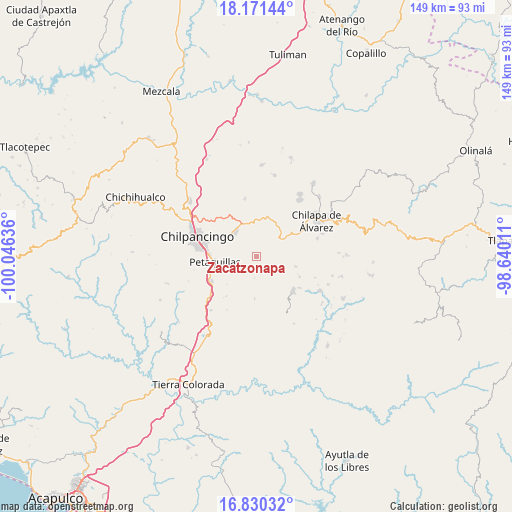
Zacatzonapa GPS coordinates[2]
17° 30' 7.632" North, 99° 20' 35.628" West
| Map corner | latitude | longitude |
|---|---|---|
| Upper-left | 18.17144°, | -100.04636° |
| Center: | 17.50212°, | -99.34323° |
| Lower-right: | 16.83032°, | -98.64011° |
| Map W x H: | 149.1×149.1 km | = 92.6×92.6mi |
| max Lat: | 32.7° ⇑83.1% North |
| Zacatzonapa: | 17.50212° |
| min Lat: | ⇓16.9% South 14.53588° |
| min Long | Zacatzonapa | max Long |
| -117.105° | -99.34323° | -86.73105° |
| W 45.3%⇐ | ⇒54.7% E |
Elevation
Elevation of Zacatzonapa is 1332 m = 4370 ft, and this is 78.3 m = 257 ft above average elevation for this country.
| Max E: |
3497 m = 11473 ft | 52.1% |
| Zacatzonapa | 1332 m 4370 ft | |
| Avg. | 1253.7 m = 4113 ft | |
Min E: |
-1 m = -3 ft | 47.9% |
See also: Mexico elevation on elevation.city.
Geographical zone
Zacatzonapa is located in North Torrid zone (between Equator and Tropic of Cancer). Distance of this Northern Tropic circle is 659.9 km =410 mi to North.| Distance of | km | miles | from Zacatzonapa |
|---|---|---|---|
| North Pole | 8061 | 5008.9 | to North |
| Arctic Circle | 5455.1 | 3389.6 | to North |
| Tropic Cancer | 659.9 | 410 | to North |
| Equator | 1946.1 | 1209.3 | to South |


Nearby cities:
15 places around Zacatzonapa: (largest is in red/bold)
• Acuentla
10.2 km =6.3 mi,  79°
79°
• Ahuexotitlán
10.9 km =6.8 mi,  74°
74°
• Chilacachapa
9.2 km =5.7 mi,  48°
48°
• Coatomatitlán
3.9 km =2.4 mi,  148°
148°
• Cuonetzingo
8.7 km =5.4 mi, 71°
• El Durazno
6.3 km =3.9 mi,  62°
62°
• Mochitlán
4.4 km =2.7 mi,  220°
220°
• Monte Alegre
5.1 km =3.2 mi,  96°
96°
• Popoyatlajco
7.8 km =4.8 mi,  91°
91°
• San Martín
6.8 km =4.2 mi,  129°
129°
• San Miguel
6.1 km =3.8 mi, 134°
• Tepechicotlán
7.9 km =4.9 mi,  254°
254°
• Tixtla de Guerrero
9.3 km =5.8 mi,  321°
321°
• Tonalapa
10.8 km =6.7 mi, 96°
• Zoquiapa
8.5 km =5.3 mi, 56°
Sources, notices
• [Note1] Compared only with cities in Mexico existing in our database
• [Src1] Map data: © OpenStreetMap contributors (CC-BY-SA)
• [Src2] Other city data from geonames.org with taken over terms of usage.
• [Src3] Geographical zone / Annual Mean Temperature by Robert A. Rohde @ Wikipedia
