Michac geodata
Michac (Puebla) is a populated place; located in Mexico in America/Mexico_City (GMT-6) time zone. With population of 1,348 people, there are 6455 cities with bigger population in this country. Compared to other cities in Mexico, 54.1% of cities are located further ↓South; 63% of cities are located further ←West and 87% of cities have lower elevation than Michac. Note1


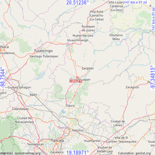
Michac GPS coordinates[2]
19° 51' 8.676" North, 98° 3' 4.572" West
| Map corner | latitude | longitude |
|---|---|---|
| Upper-left | 20.51236°, | -98.7544° |
| Center: | 19.85241°, | -98.05127° |
| Lower-right: | 19.18971°, | -97.34815° |
| Map W x H: | 147.1×147.1 km | = 91.4×91.4mi |
| max Lat: | 32.7° ⇑45.9% North |
| Michac: | 19.85241° |
| min Lat: | ⇓54.1% South 14.53588° |
| min Long | Michac | max Long |
| -117.105° | -98.05127° | -86.73105° |
| W 63%⇐ | ⇒37% E |
Elevation
Elevation of Michac is 2310 m = 7579 ft, and this is 1056.3 m = 3466 ft above average elevation for this country.
| Max E: |
3497 m = 11473 ft | 13% |
| Michac | 2310 m 7579 ft | |
| Avg. | 1253.7 m = 4113 ft | |
Min E: |
-1 m = -3 ft | 87% |
See also: Mexico elevation on elevation.city.
Geographical zone
Michac is located in North Torrid zone (between Equator and Tropic of Cancer). Distance of this Northern Tropic circle is 398.5 km =247.6 mi to North.| Distance of | km | miles | from Michac |
|---|---|---|---|
| North Pole | 7799.7 | 4846.5 | to North |
| Arctic Circle | 5193.8 | 3227.3 | to North |
| Tropic Cancer | 398.5 | 247.6 | to North |
| Equator | 2207.4 | 1371.6 | to South |


Nearby cities:
15 places around Michac: (largest is in red/bold)
• Acolihuia
10.8 km =6.7 mi,  225°
225°
• Ayotla
7.7 km =4.8 mi,  9°
9°
• Chignahuapan
2.6 km =1.6 mi,  126°
126°
• Coacoyunga
4.9 km =3 mi,  151°
151°
• Cuautelolulco
10.1 km =6.3 mi,  297°
297°
• Ixtlahuaca Barrio
4.1 km =2.5 mi,  111°
111°
• Loma Alta
6.6 km =4.1 mi,  157°
157°
• Lázaro Cárdenas (Tzitla)
4 km =2.5 mi,  183°
183°
• Matlahuacala
10.6 km =6.6 mi, 10°
• Matlahuacales Aquiles Serdán
10.1 km =6.3 mi, 181°
• Sebastopol
8.8 km =5.5 mi, 159°
• Tenextla
4.7 km =2.9 mi,  116°
116°
• Tepoxcuautla
7.5 km =4.7 mi,  40°
40°
• Tomatlán
9.4 km =5.8 mi,  60°
60°
• Villa Cuauhtémoc
9.5 km =5.9 mi,  210°
210°
Sources, notices
• [Note1] Compared only with cities in Mexico existing in our database
• [Src1] Map data: © OpenStreetMap contributors (CC-BY-SA)
• [Src2] Other city data from geonames.org with taken over terms of usage.
• [Src3] Geographical zone / Annual Mean Temperature by Robert A. Rohde @ Wikipedia
