Nogales geodata
Nogales (Querétaro) is a populated place; located in Mexico in America/Mexico_City (GMT-6) time zone. With population of 943 people, there are 9232 cities with bigger population in this country. Compared to other cities in Mexico, 71.6% of cities are located further ↓South; 65.8% of cities are located further →East and 76.4% of cities have lower elevation than Nogales. Note1


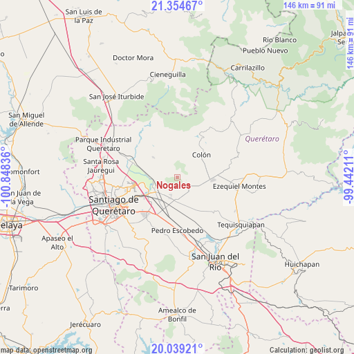
Nogales GPS coordinates[2]
20° 41' 54.132" North, 100° 8' 42.828" West
| Map corner | latitude | longitude |
|---|---|---|
| Upper-left | 21.35467°, | -100.84836° |
| Center: | 20.69837°, | -100.14523° |
| Lower-right: | 20.03921°, | -99.44211° |
| Map W x H: | 146.3×146.3 km | = 90.9×90.9mi |
| max Lat: | 32.7° ⇑28.4% North |
| Nogales: | 20.69837° |
| min Lat: | ⇓71.6% South 14.53588° |
| min Long | Nogales | max Long |
| -117.105° | -100.14523° | -86.73105° |
| W 34.2%⇐ | ⇒65.8% E |
Elevation
Elevation of Nogales is 2056 m = 6745 ft, and this is 802.3 m = 2632 ft above average elevation for this country.
| Max E: |
3497 m = 11473 ft | 23.6% |
| Nogales | 2056 m 6745 ft | |
| Avg. | 1253.7 m = 4113 ft | |
Min E: |
-1 m = -3 ft | 76.4% |
See also: Mexico elevation on elevation.city.
Geographical zone
Nogales is located in North Torrid zone (between Equator and Tropic of Cancer). Distance of this Northern Tropic circle is 304.5 km =189.2 mi to North.| Distance of | km | miles | from Nogales |
|---|---|---|---|
| North Pole | 7705.6 | 4788 | to North |
| Arctic Circle | 5099.7 | 3168.8 | to North |
| Tropic Cancer | 304.5 | 189.2 | to North |
| Equator | 2301.4 | 1430 | to South |


Nearby cities:
15 places around Nogales: (largest is in red/bold)
• Alfajayucan
9.7 km =6 mi,  309°
309°
• El Blanco
10.7 km =6.6 mi,  154°
154°
• El Gallo
10.7 km =6.6 mi,  107°
107°
• El Lobo
6.8 km =4.2 mi,  299°
299°
• Esperanza
6.8 km =4.2 mi, 148°
• Galeras
9.1 km =5.7 mi,  187°
187°
• Guadalupe la Venta
9.9 km =6.2 mi,  233°
233°
• La Griega
10.5 km =6.5 mi,  250°
250°
• Palmas
6.2 km =3.9 mi,  95°
95°
• Puerta de Enmedio
7.2 km =4.5 mi,  1°
1°
• Purísima de Cubos (La Purísima)
11.3 km =7 mi,  165°
165°
• San Miguel Amazcala
11 km =6.8 mi, 301°
• Urecho
8.9 km =5.5 mi,  123°
123°
• Viborillas
10.8 km =6.7 mi,  202°
202°
• Vista Hermosa
6.9 km =4.3 mi,  336°
336°
Sources, notices
• [Note1] Compared only with cities in Mexico existing in our database
• [Src1] Map data: © OpenStreetMap contributors (CC-BY-SA)
• [Src2] Other city data from geonames.org with taken over terms of usage.
• [Src3] Geographical zone / Annual Mean Temperature by Robert A. Rohde @ Wikipedia
