San Jerónimo Palantla geodata
San Jerónimo Palantla (Guerrero) is a populated place; located in Mexico in America/Mexico_City (GMT-6) time zone. With population of 566 people, there are 15096 cities with bigger population in this country. Compared to other cities in Mexico, 82.9% of cities are located further ↑North; 51% of cities are located further →East and 66% of cities have lower elevation than San Jerónimo Palantla. Note1


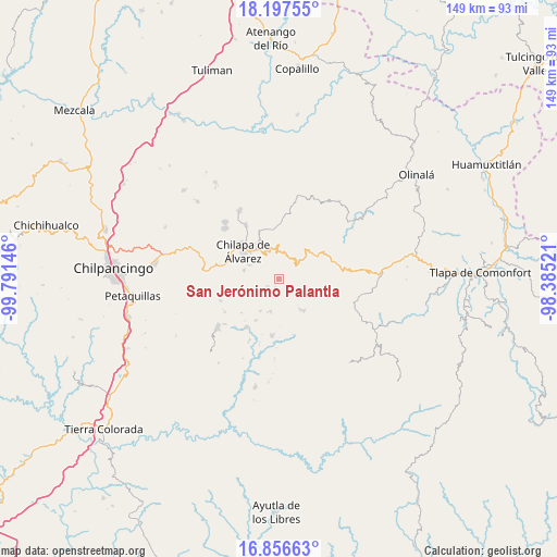
San Jerónimo Palantla GPS coordinates[2]
17° 31' 41.988" North, 99° 5' 17.988" West
| Map corner | latitude | longitude |
|---|---|---|
| Upper-left | 18.19755°, | -99.79146° |
| Center: | 17.52833°, | -99.08833° |
| Lower-right: | 16.85663°, | -98.38521° |
| Map W x H: | 149.1×149.1 km | = 92.6×92.6mi |
| max Lat: | 32.7° ⇑82.9% North |
| San Jerónimo Palantla: | 17.52833° |
| min Lat: | ⇓17.1% South 14.53588° |
| min Long | San Jerónimo P | max Long |
| -117.105° | -99.08833° | -86.73105° |
| W 49%⇐ | ⇒51% E |
Elevation
Elevation of San Jerónimo Palantla is 1852 m = 6076 ft, and this is 598.3 m = 1963 ft above average elevation for this country.
| Max E: |
3497 m = 11473 ft | 34% |
| San Jerónimo Palantla | 1852 m 6076 ft | |
| Avg. | 1253.7 m = 4113 ft | |
Min E: |
-1 m = -3 ft | 66% |
See also: Mexico elevation on elevation.city.
Geographical zone
San Jerónimo Palantla is located in North Torrid zone (between Equator and Tropic of Cancer). Distance of this Northern Tropic circle is 657 km =408.2 mi to North.| Distance of | km | miles | from San Jerónimo Palantla |
|---|---|---|---|
| North Pole | 8058.1 | 5007.1 | to North |
| Arctic Circle | 5452.2 | 3387.8 | to North |
| Tropic Cancer | 657 | 408.2 | to North |
| Equator | 1949 | 1211.1 | to South |


Nearby cities:
15 places around San Jerónimo Palantla: (largest is in red/bold)
• Ahuixtla
5.5 km =3.4 mi,  87°
87°
• Alcozacán
2.7 km =1.7 mi,  194°
194°
• Atenxoxola
7.3 km =4.5 mi,  232°
232°
• Atzacoaloya
5.6 km =3.5 mi,  291°
291°
• El Jagüey
7.4 km =4.6 mi,  235°
235°
• Macuixcatlán
8.3 km =5.2 mi,  295°
295°
• Tepetlacingo
7.2 km =4.5 mi, 301°
• Tepozonalco
7.9 km =4.9 mi,  51°
51°
• Tlalixtlahuacán
5.8 km =3.6 mi,  214°
214°
• Tlanipatla
6.2 km =3.9 mi,  275°
275°
• Trigomila
7.5 km =4.7 mi,  324°
324°
• Xochitempa
8.6 km =5.3 mi,  269°
269°
• Zinzintitlán
6.9 km =4.3 mi, 278°
• Zizicazapa
7 km =4.3 mi,  258°
258°
• Zompeltepec
4.4 km =2.7 mi,  37°
37°
Sources, notices
• [Note1] Compared only with cities in Mexico existing in our database
• [Src1] Map data: © OpenStreetMap contributors (CC-BY-SA)
• [Src2] Other city data from geonames.org with taken over terms of usage.
• [Src3] Geographical zone / Annual Mean Temperature by Robert A. Rohde @ Wikipedia
