Almolonga geodata
Almolonga (Veracruz) is a populated place; located in Mexico in America/Mexico_City (GMT-6) time zone. With population of 855 people, there are 10232 cities with bigger population in this country. Compared to other cities in Mexico, 52.1% of cities are located further ↑North; 77.5% of cities are located further ←West and 64.3% of cities have higher elevation than Almolonga. Note1


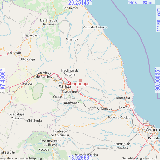
Almolonga GPS coordinates[2]
19° 35' 25.44" North, 96° 47' 0.492" West
| Map corner | latitude | longitude |
|---|---|---|
| Upper-left | 20.25145°, | -97.4866° |
| Center: | 19.5904°, | -96.78347° |
| Lower-right: | 18.92663°, | -96.08035° |
| Map W x H: | 147.3×147.3 km | = 91.5×91.5mi |
| max Lat: | 32.7° ⇑52.1% North |
| Almolonga: | 19.5904° |
| min Lat: | ⇓47.9% South 14.53588° |
| min Long | Almolonga | max Long |
| -117.105° | -96.78347° | -86.73105° |
| W 77.5%⇐ | ⇒22.5% E |
Elevation
Elevation of Almolonga is 732 m = 2402 ft, and this is 521.7 m = 1712 ft below average elevation for this country.
| Max E: |
3497 m = 11473 ft | 64.3% |
| Avg. | 1253.7 m = 4113 ft | |
| Almolonga | 732 m = 2402 ft | |
Min E: |
-1 m = -3 ft | 35.7% |
See also: Mexico elevation on elevation.city.
Geographical zone
Almolonga is located in North Torrid zone (between Equator and Tropic of Cancer). Distance of this Northern Tropic circle is 427.7 km =265.8 mi to North.| Distance of | km | miles | from Almolonga |
|---|---|---|---|
| North Pole | 7828.8 | 4864.6 | to North |
| Arctic Circle | 5222.9 | 3245.4 | to North |
| Tropic Cancer | 427.7 | 265.8 | to North |
| Equator | 2178.2 | 1353.5 | to South |


Nearby cities:
15 places around Almolonga: (largest is in red/bold)
• Alto Lucero
6.4 km =4 mi,  53°
53°
• Cerrillos de Diaz
7.5 km =4.7 mi, 54°
• Chiltoyac
8.8 km =5.5 mi,  260°
260°
• El Terrero
6.1 km =3.8 mi,  195°
195°
• La Tinaja
8.7 km =5.4 mi,  160°
160°
• Las Haldas
6.1 km =3.8 mi,  314°
314°
• Mafafas
8.1 km =5 mi,  20°
20°
• Mesa de Guadalupe
9.3 km =5.8 mi,  108°
108°
• San Antonio Paso del Toro
5.8 km =3.6 mi, 262°
• San Nicolás
4.1 km =2.5 mi, 158°
• Seis de Enero
5.7 km =3.5 mi,  244°
244°
• Tenampa
8.5 km =5.3 mi,  285°
285°
• Trapiche del Rosario
6.9 km =4.3 mi,  139°
139°
• Tronconal
8.9 km =5.5 mi,  250°
250°
• Vicente Guerrero (Tepetates)
3.3 km =2.1 mi, 312°
Sources, notices
• [Note1] Compared only with cities in Mexico existing in our database
• [Src1] Map data: © OpenStreetMap contributors (CC-BY-SA)
• [Src2] Other city data from geonames.org with taken over terms of usage.
• [Src3] Geographical zone / Annual Mean Temperature by Robert A. Rohde @ Wikipedia
