La Reforma geodata
La Reforma (Guanajuato) is a populated place; located in Mexico in America/Mexico_City (GMT-6) time zone. With population of 517 people, there are 16282 cities with bigger population in this country. Compared to other cities in Mexico, 77.2% of cities are located further ↓South; 68.3% of cities are located further →East and 77.2% of cities have lower elevation than La Reforma. Note1


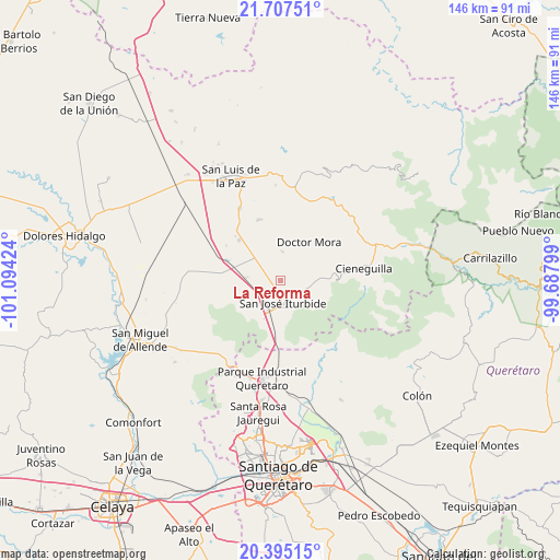
La Reforma GPS coordinates[2]
21° 3' 10.008" North, 100° 23' 27.996" West
| Map corner | latitude | longitude |
|---|---|---|
| Upper-left | 21.70751°, | -101.09424° |
| Center: | 21.05278°, | -100.39111° |
| Lower-right: | 20.39515°, | -99.68799° |
| Map W x H: | 145.9×145.9 km | = 90.7×90.7mi |
| max Lat: | 32.7° ⇑22.8% North |
| La Reforma: | 21.05278° |
| min Lat: | ⇓77.2% South 14.53588° |
| min Long | La Reforma | max Long |
| -117.105° | -100.39111° | -86.73105° |
| W 31.7%⇐ | ⇒68.3% E |
Elevation
Elevation of La Reforma is 2072 m = 6798 ft, and this is 818.3 m = 2685 ft above average elevation for this country.
| Max E: |
3497 m = 11473 ft | 22.8% |
| La Reforma | 2072 m 6798 ft | |
| Avg. | 1253.7 m = 4113 ft | |
Min E: |
-1 m = -3 ft | 77.2% |
See also: Mexico elevation on elevation.city.
Geographical zone
La Reforma is located in North Torrid zone (between Equator and Tropic of Cancer). Distance of this Northern Tropic circle is 265.1 km =164.7 mi to North.| Distance of | km | miles | from La Reforma |
|---|---|---|---|
| North Pole | 7666.2 | 4763.6 | to North |
| Arctic Circle | 5060.3 | 3144.3 | to North |
| Tropic Cancer | 265.1 | 164.7 | to North |
| Equator | 2340.8 | 1454.5 | to South |


Nearby cities:
15 places around La Reforma: (largest is in red/bold)
• Cinco de Mayo
4.7 km =2.9 mi,  213°
213°
• El Capulín
7.3 km =4.5 mi,  100°
100°
• El Pinito
6 km =3.7 mi,  185°
185°
• Galomo
4.7 km =2.9 mi,  280°
280°
• La Ciénega
6.7 km =4.2 mi, 100°
• La Huerta
7.7 km =4.8 mi, 192°
• La Noria
7.4 km =4.6 mi,  5°
5°
• La Yerbabuena
4.5 km =2.8 mi,  118°
118°
• Las Adjuntas
2.5 km =1.6 mi,  290°
290°
• Miranda
6.7 km =4.2 mi,  65°
65°
• Morisquilla
6.2 km =3.9 mi,  45°
45°
• Prados del Rosario
3.4 km =2.1 mi,  182°
182°
• Pueblo Nuevo
5.4 km =3.4 mi,  342°
342°
• San José Iturbide
5.7 km =3.5 mi,  172°
172°
• Santa Anita
7.1 km =4.4 mi, 122°
Sources, notices
• [Note1] Compared only with cities in Mexico existing in our database
• [Src1] Map data: © OpenStreetMap contributors (CC-BY-SA)
• [Src2] Other city data from geonames.org with taken over terms of usage.
• [Src3] Geographical zone / Annual Mean Temperature by Robert A. Rohde @ Wikipedia
