Pueblo Nuevo geodata
Pueblo Nuevo (Guanajuato) is a populated place; located in Mexico in America/Mexico_City (GMT-6) time zone. With population of 590 people, there are 14554 cities with bigger population in this country. Compared to other cities in Mexico, 77.8% of cities are located further ↓South; 68.5% of cities are located further →East and 76.1% of cities have lower elevation than Pueblo Nuevo. Note1


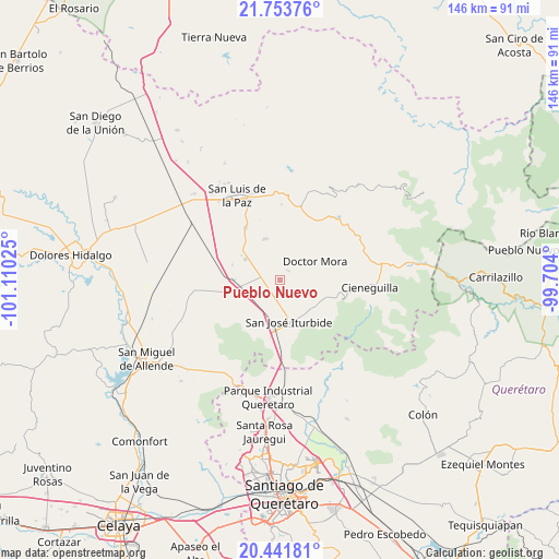
Pueblo Nuevo GPS coordinates[2]
21° 5' 57.228" North, 100° 24' 25.632" West
| Map corner | latitude | longitude |
|---|---|---|
| Upper-left | 21.75376°, | -101.11025° |
| Center: | 21.09923°, | -100.40712° |
| Lower-right: | 20.44181°, | -99.704° |
| Map W x H: | 145.9×145.9 km | = 90.7×90.7mi |
| max Lat: | 32.7° ⇑22.2% North |
| Pueblo Nuevo: | 21.09923° |
| min Lat: | ⇓77.8% South 14.53588° |
| min Long | Pueblo Nuevo | max Long |
| -117.105° | -100.40712° | -86.73105° |
| W 31.5%⇐ | ⇒68.5% E |
Elevation
Elevation of Pueblo Nuevo is 2050 m = 6726 ft, and this is 796.3 m = 2613 ft above average elevation for this country.
| Max E: |
3497 m = 11473 ft | 23.9% |
| Pueblo Nuevo | 2050 m 6726 ft | |
| Avg. | 1253.7 m = 4113 ft | |
Min E: |
-1 m = -3 ft | 76.1% |
See also: Mexico elevation on elevation.city.
Geographical zone
Pueblo Nuevo is located in North Torrid zone (between Equator and Tropic of Cancer). Distance of this Northern Tropic circle is 259.9 km =161.5 mi to North.| Distance of | km | miles | from Pueblo Nuevo |
|---|---|---|---|
| North Pole | 7661 | 4760.3 | to North |
| Arctic Circle | 5055.2 | 3141.2 | to North |
| Tropic Cancer | 259.9 | 161.5 | to North |
| Equator | 2346 | 1457.7 | to South |


Nearby cities:
15 places around Pueblo Nuevo: (largest is in red/bold)
• Cinco de Mayo
9.1 km =5.7 mi,  185°
185°
• Galomo
5.2 km =3.2 mi,  214°
214°
• La Laguna
5.9 km =3.7 mi,  291°
291°
• La Noria
3.3 km =2.1 mi,  47°
47°
• La Redonda
9.5 km =5.9 mi,  101°
101°
• La Reforma
5.4 km =3.4 mi,  162°
162°
• La Yerbabuena
9.2 km =5.7 mi,  142°
142°
• Las Adjuntas
4.4 km =2.7 mi, 188°
• Miranda
8.1 km =5 mi,  106°
106°
• Morisquilla
6.2 km =3.9 mi, 97°
• Prados del Rosario
8.7 km =5.4 mi,  169°
169°
• San Rafael
6.6 km =4.1 mi,  55°
55°
• San Sebastián de Salitre
7.7 km =4.8 mi,  272°
272°
• Tulillos de Abajo
8.1 km =5 mi,  259°
259°
• Tulillos de Arriba
7.2 km =4.5 mi,  244°
244°
Sources, notices
• [Note1] Compared only with cities in Mexico existing in our database
• [Src1] Map data: © OpenStreetMap contributors (CC-BY-SA)
• [Src2] Other city data from geonames.org with taken over terms of usage.
• [Src3] Geographical zone / Annual Mean Temperature by Robert A. Rohde @ Wikipedia
