Morisquilla geodata
Morisquilla (Guanajuato) is a populated place; located in Mexico in America/Mexico_City (GMT-6) time zone. With population of 584 people, there are 14684 cities with bigger population in this country. Compared to other cities in Mexico, 77.7% of cities are located further ↓South; 67.9% of cities are located further →East and 77.9% of cities have lower elevation than Morisquilla. Note1


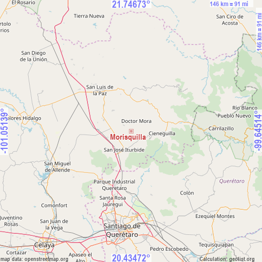
Morisquilla GPS coordinates[2]
21° 5' 31.812" North, 100° 20' 53.736" West
| Map corner | latitude | longitude |
|---|---|---|
| Upper-left | 21.74673°, | -101.05139° |
| Center: | 21.09217°, | -100.34826° |
| Lower-right: | 20.43472°, | -99.64514° |
| Map W x H: | 145.9×145.9 km | = 90.7×90.7mi |
| max Lat: | 32.7° ⇑22.3% North |
| Morisquilla: | 21.09217° |
| min Lat: | ⇓77.7% South 14.53588° |
| min Long | Morisquilla | max Long |
| -117.105° | -100.34826° | -86.73105° |
| W 32.1%⇐ | ⇒67.9% E |
Elevation
Elevation of Morisquilla is 2086 m = 6844 ft, and this is 832.3 m = 2731 ft above average elevation for this country.
| Max E: |
3497 m = 11473 ft | 22.1% |
| Morisquilla | 2086 m 6844 ft | |
| Avg. | 1253.7 m = 4113 ft | |
Min E: |
-1 m = -3 ft | 77.9% |
See also: Mexico elevation on elevation.city.
Geographical zone
Morisquilla is located in North Torrid zone (between Equator and Tropic of Cancer). Distance of this Northern Tropic circle is 260.7 km =162 mi to North.| Distance of | km | miles | from Morisquilla |
|---|---|---|---|
| North Pole | 7661.8 | 4760.8 | to North |
| Arctic Circle | 5055.9 | 3141.6 | to North |
| Tropic Cancer | 260.7 | 162 | to North |
| Equator | 2345.2 | 1457.2 | to South |


Nearby cities:
15 places around Morisquilla: (largest is in red/bold)
• Carbajal
9 km =5.6 mi,  117°
117°
• Derramadero de Charcas
4.6 km =2.9 mi,  65°
65°
• Doctor Mora
6.3 km =3.9 mi,  27°
27°
• El Capulín
6.4 km =4 mi,  154°
154°
• La Ciénega
6 km =3.7 mi,  159°
159°
• La Noria
4.8 km =3 mi,  309°
309°
• La Redonda
3.4 km =2.1 mi,  108°
108°
• La Reforma
6.2 km =3.9 mi,  225°
225°
• La Yerbabuena
6.6 km =4.1 mi,  184°
184°
• Las Adjuntas
7.6 km =4.7 mi,  242°
242°
• Miranda
2.3 km =1.4 mi,  133°
133°
• Pueblo Nuevo
6.2 km =3.9 mi,  277°
277°
• San Rafael
4.6 km =2.9 mi,  351°
351°
• Santa Anita
8.3 km =5.2 mi,  169°
169°
• Vagui
7.8 km =4.8 mi,  5°
5°
Sources, notices
• [Note1] Compared only with cities in Mexico existing in our database
• [Src1] Map data: © OpenStreetMap contributors (CC-BY-SA)
• [Src2] Other city data from geonames.org with taken over terms of usage.
• [Src3] Geographical zone / Annual Mean Temperature by Robert A. Rohde @ Wikipedia
