Acolihuia geodata
Acolihuia (Puebla) is a populated place; located in Mexico in America/Mexico_City (GMT-6) time zone. With population of 505 people, there are 16660 cities with bigger population in this country. Compared to other cities in Mexico, 52.4% of cities are located further ↓South; 62.2% of cities are located further ←West and 90.1% of cities have lower elevation than Acolihuia. Note1


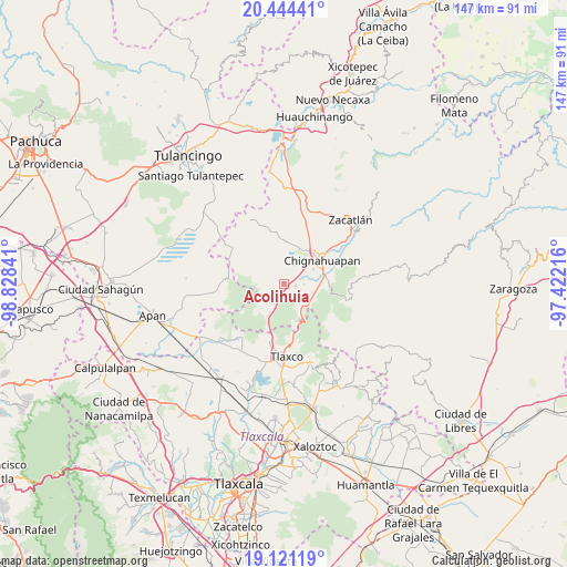
Acolihuia GPS coordinates[2]
19° 47' 3.012" North, 98° 7' 31.008" West
| Map corner | latitude | longitude |
|---|---|---|
| Upper-left | 20.44441°, | -98.82841° |
| Center: | 19.78417°, | -98.12528° |
| Lower-right: | 19.12119°, | -97.42216° |
| Map W x H: | 147.1×147.1 km | = 91.4×91.4mi |
| max Lat: | 32.7° ⇑47.6% North |
| Acolihuia: | 19.78417° |
| min Lat: | ⇓52.4% South 14.53588° |
| min Long | Acolihuia | max Long |
| -117.105° | -98.12528° | -86.73105° |
| W 62.2%⇐ | ⇒37.8% E |
Elevation
Elevation of Acolihuia is 2409 m = 7904 ft, and this is 1155.3 m = 3790 ft above average elevation for this country.
| Max E: |
3497 m = 11473 ft | 9.9% |
| Acolihuia | 2409 m 7904 ft | |
| Avg. | 1253.7 m = 4113 ft | |
Min E: |
-1 m = -3 ft | 90.1% |
See also: Mexico elevation on elevation.city.
Geographical zone
Acolihuia is located in North Torrid zone (between Equator and Tropic of Cancer). Distance of this Northern Tropic circle is 406.1 km =252.3 mi to North.| Distance of | km | miles | from Acolihuia |
|---|---|---|---|
| North Pole | 7807.3 | 4851.2 | to North |
| Arctic Circle | 5201.4 | 3232 | to North |
| Tropic Cancer | 406.1 | 252.3 | to North |
| Equator | 2199.8 | 1366.9 | to South |


Nearby cities:
15 places around Acolihuia: (largest is in red/bold)
• Chignahuapan
11.5 km =7.1 mi,  58°
58°
• Coacoyunga
10.6 km =6.6 mi,  71°
71°
• Cuautelolulco
12.3 km =7.6 mi,  354°
354°
• El Fresno
7.8 km =4.8 mi,  140°
140°
• Ixtlahuaca Barrio
13.1 km =8.1 mi, 62°
• Llano Verde
2.8 km =1.7 mi,  173°
173°
• Loma Alta
10.4 km =6.5 mi,  81°
81°
• Los Ranchos (Rinconada)
10.1 km =6.3 mi,  226°
226°
• Lázaro Cárdenas (Tzitla)
8.3 km =5.2 mi, 64°
• Matlahuacales Aquiles Serdán
7.9 km =4.9 mi,  108°
108°
• Michac
10.8 km =6.7 mi,  45°
45°
• Rinconada
10.2 km =6.3 mi,  220°
220°
• San Antonio Matlahuacales
5.6 km =3.5 mi,  125°
125°
• Sebastopol
10.9 km =6.8 mi,  93°
93°
• Villa Cuauhtémoc
3 km =1.9 mi,  102°
102°
Sources, notices
• [Note1] Compared only with cities in Mexico existing in our database
• [Src1] Map data: © OpenStreetMap contributors (CC-BY-SA)
• [Src2] Other city data from geonames.org with taken over terms of usage.
• [Src3] Geographical zone / Annual Mean Temperature by Robert A. Rohde @ Wikipedia
