Presa Nueva geodata
Presa Nueva (Zacatecas) is a populated place; located in Mexico in America/Mexico_City (GMT-6) time zone. With population of 503 people, there are 16722 cities with bigger population in this country. Compared to other cities in Mexico, 84.9% of cities are located further ↓South; 78.8% of cities are located further →East and 81.2% of cities have lower elevation than Presa Nueva. Note1


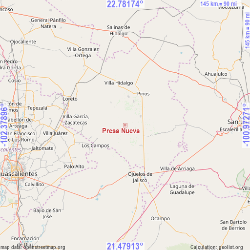
Presa Nueva GPS coordinates[2]
22° 7' 54.984" North, 101° 40' 32.988" West
| Map corner | latitude | longitude |
|---|---|---|
| Upper-left | 22.78174°, | -102.37896° |
| Center: | 22.13194°, | -101.67583° |
| Lower-right: | 21.47913°, | -100.97271° |
| Map W x H: | 144.8×144.8 km | = 90×90mi |
| max Lat: | 32.7° ⇑15.1% North |
| Presa Nueva: | 22.13194° |
| min Lat: | ⇓84.9% South 14.53588° |
| min Long | Presa Nueva | max Long |
| -117.105° | -101.67583° | -86.73105° |
| W 21.2%⇐ | ⇒78.8% E |
Elevation
Elevation of Presa Nueva is 2168 m = 7113 ft, and this is 914.3 m = 3000 ft above average elevation for this country.
| Max E: |
3497 m = 11473 ft | 18.8% |
| Presa Nueva | 2168 m 7113 ft | |
| Avg. | 1253.7 m = 4113 ft | |
Min E: |
-1 m = -3 ft | 81.2% |
See also: Mexico elevation on elevation.city.
Geographical zone
Presa Nueva is located in North Torrid zone (between Equator and Tropic of Cancer). Distance of this Northern Tropic circle is 145.1 km =90.2 mi to North.| Distance of | km | miles | from Presa Nueva |
|---|---|---|---|
| North Pole | 7546.2 | 4689 | to North |
| Arctic Circle | 4940.3 | 3069.8 | to North |
| Tropic Cancer | 145.1 | 90.2 | to North |
| Equator | 2460.8 | 1529.1 | to South |


Nearby cities:
15 places around Presa Nueva: (largest is in red/bold)
• El Nigromante
4.3 km =2.7 mi,  304°
304°
• El Obraje
10.3 km =6.4 mi,  58°
58°
• Emilio Carranza
17.4 km =10.8 mi,  288°
288°
• Estancia de Guadalupe
16.6 km =10.3 mi,  6°
6°
• Jaula de Abajo
14.4 km =8.9 mi,  143°
143°
• Jaula de Arriba
16.1 km =10 mi,  131°
131°
• José María Morelos
15.5 km =9.6 mi,  87°
87°
• La Blanca (Chihuahua)
12.8 km =8 mi,  116°
116°
• La Laborcilla
5.8 km =3.6 mi,  241°
241°
• La Pachona
12.5 km =7.8 mi,  328°
328°
• La Puerta de Jalisco
12 km =7.5 mi, 287°
• La Victoria
14.7 km =9.1 mi,  18°
18°
• Ojo de Agua de la Palma
15.2 km =9.4 mi,  200°
200°
• Pedregoso
15.9 km =9.9 mi, 327°
• San José de Castellanos
13.1 km =8.1 mi,  101°
101°
Sources, notices
• [Note1] Compared only with cities in Mexico existing in our database
• [Src1] Map data: © OpenStreetMap contributors (CC-BY-SA)
• [Src2] Other city data from geonames.org with taken over terms of usage.
• [Src3] Geographical zone / Annual Mean Temperature by Robert A. Rohde @ Wikipedia
