El Obraje geodata
El Obraje (Zacatecas) is a populated place; located in Mexico in America/Mexico_City (GMT-6) time zone. With population of 1,980 people, there are 4401 cities with bigger population in this country. Compared to other cities in Mexico, 85.1% of cities are located further ↓South; 78.1% of cities are located further →East and 82.6% of cities have lower elevation than El Obraje. Note1


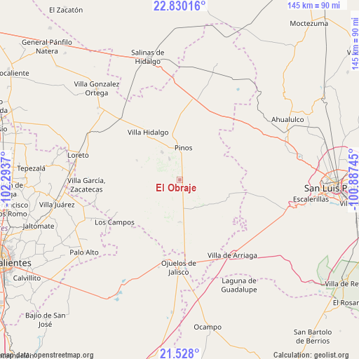
El Obraje GPS coordinates[2]
22° 10' 50.124" North, 101° 35' 26.052" West
| Map corner | latitude | longitude |
|---|---|---|
| Upper-left | 22.83016°, | -102.2937° |
| Center: | 22.18059°, | -101.59057° |
| Lower-right: | 21.528°, | -100.88745° |
| Map W x H: | 144.8×144.8 km | = 90×90mi |
| max Lat: | 32.7° ⇑14.9% North |
| El Obraje: | 22.18059° |
| min Lat: | ⇓85.1% South 14.53588° |
| min Long | El Obraje | max Long |
| -117.105° | -101.59057° | -86.73105° |
| W 21.9%⇐ | ⇒78.1% E |
Elevation
Elevation of El Obraje is 2205 m = 7234 ft, and this is 951.3 m = 3121 ft above average elevation for this country.
| Max E: |
3497 m = 11473 ft | 17.4% |
| El Obraje | 2205 m 7234 ft | |
| Avg. | 1253.7 m = 4113 ft | |
Min E: |
-1 m = -3 ft | 82.6% |
See also: Mexico elevation on elevation.city.
Geographical zone
El Obraje is located in North Torrid zone (between Equator and Tropic of Cancer). Distance of this Northern Tropic circle is 139.7 km =86.8 mi to North.| Distance of | km | miles | from El Obraje |
|---|---|---|---|
| North Pole | 7540.8 | 4685.6 | to North |
| Arctic Circle | 4934.9 | 3066.4 | to North |
| Tropic Cancer | 139.7 | 86.8 | to North |
| Equator | 2466.3 | 1532.5 | to South |


Nearby cities:
15 places around El Obraje: (largest is in red/bold)
• Cieneguilla
16.7 km =10.4 mi,  81°
81°
• El Nigromante
12.7 km =7.9 mi,  256°
256°
• Estancia de Guadalupe
13.1 km =8.1 mi,  328°
328°
• Jaula de Abajo
16.9 km =10.5 mi,  180°
180°
• Jaula de Arriba
16.3 km =10.1 mi,  168°
168°
• José María Morelos
8.2 km =5.1 mi,  124°
124°
• La Blanca (Chihuahua)
11.4 km =7.1 mi, 166°
• La Estrella
15.3 km =9.5 mi,  132°
132°
• La Laborcilla
16.1 km =10 mi,  239°
239°
• La Lobeña
16.8 km =10.4 mi,  317°
317°
• La Pachona
16.2 km =10.1 mi,  288°
288°
• La Victoria
9.4 km =5.8 mi, 334°
• Pinos
12.9 km =8 mi,  6°
6°
• Presa Nueva
10.3 km =6.4 mi, 238°
• San José de Castellanos
8.9 km =5.5 mi,  152°
152°
Sources, notices
• [Note1] Compared only with cities in Mexico existing in our database
• [Src1] Map data: © OpenStreetMap contributors (CC-BY-SA)
• [Src2] Other city data from geonames.org with taken over terms of usage.
• [Src3] Geographical zone / Annual Mean Temperature by Robert A. Rohde @ Wikipedia
