Marudi geodata
Marudi (Sarawak) is a populated place; located in Malaysia in Asia/Kuching (GMT+8) time zone. With population of 90,100 people, there are 39 cities with bigger population in this country. Compared to other cities in Malaysia, 52.8% of cities are located further ↓South; 87.6% of cities are located further ←West and 52.2% of cities have lower elevation than Marudi. Note1


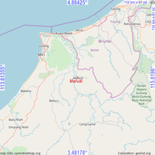
Marudi GPS coordinates[2]
4° 10' 59.988" North, 114° 19' 0.012" East
| Map corner | latitude | longitude |
|---|---|---|
| Upper-left | 4.88425°, | 113.61355° |
| Center: | 4.18333°, | 114.31667° |
| Lower-right: | 3.48178°, | 115.0198° |
| Map W x H: | 155.9×155.9 km | = 96.9×96.9mi |
| max Lat: | 6.88732° ⇑47.2% North |
| Marudi: | 4.18333° |
| min Lat: | ⇓52.8% South 1.24722° |
| min Long | Marudi | max Long |
| 99.68252° | 114.31667° | 118.61119° |
| W 87.6%⇐ | ⇒12.4% E |
Elevation
Elevation of Marudi is 15 m = 49 ft, and this is 29.7 m = 97 ft below average elevation for this country.
| Max E: |
1488 m = 4882 ft | 47.8% |
| Avg. | 44.7 m = 147 ft | |
| Marudi | 15 m = 49 ft | |
Min E: |
0 m = 0 ft | 52.2% |
See also: Marudi elevation on elevation.city.
Geographical zone
Marudi is located in North Torrid zone (between Equator and Tropic of Cancer). Distance of Equator is 465.1 km =289 mi to South.| Distance of | km | miles | from Marudi |
|---|---|---|---|
| North Pole | 9541.9 | 5929.1 | to North |
| Arctic Circle | 6936 | 4309.8 | to North |
| Tropic Cancer | 2140.8 | 1330.2 | to North |
| Equator | 465.1 | 289 | to South |


Nearby cities:
15 places around Marudi: (largest is in red/bold)
• Bandar Labuan
162 km =100.7 mi,  40°
40°
• Batu Niah
75.9 km =47.2 mi,  235°
235°
• Beaufort
204.5 km =127.1 mi,  50°
50°
• Bintulu
181.8 km =113 mi,  231°
231°
• Data Kakus
186.6 km =115.9 mi,  204°
204°
• Keningau
241.3 km =149.9 mi,  57°
57°
• Kg Ramayah
272.9 km =169.6 mi, 46°
• Kinarut
264.5 km =164.4 mi, 46°
• Labuan
159.7 km =99.2 mi, 40°
• Lawas
142.6 km =88.6 mi, 58°
• Lidung Jelo
178.4 km =110.9 mi,  163°
163°
• Limbang
98.5 km =61.2 mi, 50°
• Long Ampan Aing or Abanang
176 km =109.4 mi, 164°
• Miri
43.3 km =26.9 mi,  303°
303°
• Papar
248.5 km =154.4 mi, 46°
Sources, notices
• [Note1] Compared only with cities in Malaysia existing in our database
• [Src1] Map data: © OpenStreetMap contributors (CC-BY-SA)
• [Src2] Other city data from geonames.org with taken over terms of usage.
• [Src3] Geographical zone / Annual Mean Temperature by Robert A. Rohde @ Wikipedia
