Lawas geodata
Lawas (Sarawak) is a populated place; located in Malaysia in Asia/Kuching (GMT+8) time zone. With population of 38,385 people, there are 78 cities with bigger population in this country. Compared to other cities in Malaysia, 62.4% of cities are located further ↓South; 91% of cities are located further ←West and 64.6% of cities have higher elevation than Lawas. Note1


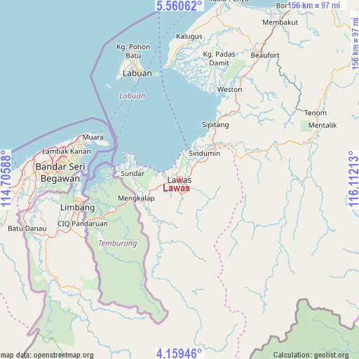
Lawas GPS coordinates[2]
4° 51' 37.44" North, 115° 24' 32.4" East
| Map corner | latitude | longitude |
|---|---|---|
| Upper-left | 5.56062°, | 114.70588° |
| Center: | 4.8604°, | 115.409° |
| Lower-right: | 4.15946°, | 116.11213° |
| Map W x H: | 155.8×155.8 km | = 96.8×96.8mi |
| max Lat: | 6.88732° ⇑37.6% North |
| Lawas: | 4.8604° |
| min Lat: | ⇓62.4% South 1.24722° |
| min Long | Lawas | max Long |
| 99.68252° | 115.409° | 118.61119° |
| W 91%⇐ | ⇒9% E |
Elevation
Elevation of Lawas is 10 m = 33 ft, and this is 34.7 m = 114 ft below average elevation for this country.
| Max E: |
1488 m = 4882 ft | 64.6% |
| Avg. | 44.7 m = 147 ft | |
| Lawas | 10 m = 33 ft | |
Min E: |
0 m = 0 ft | 35.4% |
See also: Malaysia elevation on elevation.city.
Geographical zone
Lawas is located in North Torrid zone (between Equator and Tropic of Cancer). Distance of Equator is 540.4 km =335.8 mi to South.| Distance of | km | miles | from Lawas |
|---|---|---|---|
| North Pole | 9466.6 | 5882.3 | to North |
| Arctic Circle | 6860.7 | 4263 | to North |
| Tropic Cancer | 2065.5 | 1283.4 | to North |
| Equator | 540.4 | 335.8 | to South |


Nearby cities:
15 places around Lawas: (largest is in red/bold)
• Bandar Labuan
50.1 km =31.1 mi,  341°
341°
• Beaufort
65.7 km =40.8 mi,  34°
34°
• Donggongon
139.4 km =86.6 mi, 33°
• Keningau
98.7 km =61.3 mi,  57°
57°
• Kg Ramayah
136.7 km =84.9 mi, 33°
• Kinarut
128.2 km =79.7 mi, 33°
• Kota Belud
200.6 km =124.6 mi, 34°
• Kota Kinabalu
144 km =89.5 mi, 30°
• Labuan
50 km =31.1 mi, 339°
• Limbang
46.9 km =29.1 mi,  254°
254°
• Marudi
142.6 km =88.6 mi,  238°
238°
• Miri
165.2 km =102.7 mi, 251°
• Papar
113.1 km =70.3 mi, 30°
• Putatan
138.7 km =86.2 mi, 31°
• Ranau
184.6 km =114.7 mi,  48°
48°
Sources, notices
• [Note1] Compared only with cities in Malaysia existing in our database
• [Src1] Map data: © OpenStreetMap contributors (CC-BY-SA)
• [Src2] Other city data from geonames.org with taken over terms of usage.
• [Src3] Geographical zone / Annual Mean Temperature by Robert A. Rohde @ Wikipedia
