Kampong Kadok geodata
Kampong Kadok (Kelantan) is a populated place; located in Malaysia in Asia/Kuala_Lumpur (GMT+8) time zone. With population of 19,233 people, there are 125 cities with bigger population in this country. Compared to other cities in Malaysia, 88.2% of cities are located further ↓South; 57.3% of cities are located further ←West and 56.2% of cities have higher elevation than Kampong Kadok. Note1


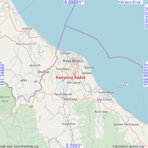
Kampong Kadok GPS coordinates[2]
6° 0' 0" North, 102° 15' 0" East
| Map corner | latitude | longitude |
|---|---|---|
| Upper-left | 6.69881°, | 101.54688° |
| Center: | 6°, | 102.25° |
| Lower-right: | 5.3003°, | 102.95313° |
| Map W x H: | 155.5×155.5 km | = 96.6×96.6mi |
| max Lat: | 6.88732° ⇑11.8% North |
| Kampong Kadok: | 6° |
| min Lat: | ⇓88.2% South 1.24722° |
| min Long | Kampong Kadok | max Long |
| 99.68252° | 102.25° | 118.61119° |
| W 57.3%⇐ | ⇒42.7% E |
Elevation
Elevation of Kampong Kadok is 12 m = 39 ft, and this is 32.7 m = 107 ft below average elevation for this country.
| Max E: |
1488 m = 4882 ft | 56.2% |
| Avg. | 44.7 m = 147 ft | |
| Kampong Kadok | 12 m = 39 ft | |
Min E: |
0 m = 0 ft | 43.8% |
See also: Malaysia elevation on elevation.city.
Geographical zone
Kampong Kadok is located in North Torrid zone (between Equator and Tropic of Cancer). Distance of Equator is 667.1 km =414.5 mi to South.| Distance of | km | miles | from Kampong Kadok |
|---|---|---|---|
| North Pole | 9339.9 | 5803.5 | to North |
| Arctic Circle | 6734 | 4184.3 | to North |
| Tropic Cancer | 1938.8 | 1204.7 | to North |
| Equator | 667.1 | 414.5 | to South |


Nearby cities:
15 places around Kampong Kadok: (largest is in red/bold)
• Gua Musang
127.9 km =79.5 mi,  194°
194°
• Jertih
39.8 km =24.7 mi,  138°
138°
• Kampong Pangkal Kalong
10 km =6.2 mi,  201°
201°
• Kampung Kuala Besut
38.1 km =23.7 mi,  119°
119°
• Kampung Lemal
12.5 km =7.8 mi,  285°
285°
• Ketereh
4.8 km =3 mi,  182°
182°
• Kota Bharu
13.8 km =8.6 mi,  356°
356°
• Kuala Besut
38.5 km =23.9 mi, 118°
• Kuala Terengganu
123.5 km =76.7 mi,  127°
127°
• Marang
137.8 km =85.6 mi, 129°
• Pasir Mas
13.4 km =8.3 mi, 294°
• Peringat
5.2 km =3.2 mi,  44°
44°
• Pulai Chondong
14.4 km =8.9 mi, 188°
• Tanah Merah
24.8 km =15.4 mi,  206°
206°
• Tumpat
23.7 km =14.7 mi,  338°
338°
Sources, notices
• [Note1] Compared only with cities in Malaysia existing in our database
• [Src1] Map data: © OpenStreetMap contributors (CC-BY-SA)
• [Src2] Other city data from geonames.org with taken over terms of usage.
• [Src3] Geographical zone / Annual Mean Temperature by Robert A. Rohde @ Wikipedia
