Marang geodata
Marang (Terengganu) is a populated place; located in Malaysia in Asia/Kuala_Lumpur (GMT+8) time zone. With population of 21,410 people, there are 113 cities with bigger population in this country. Compared to other cities in Malaysia, 66.3% of cities are located further ↓South; 70.8% of cities are located further ←West and 50.6% of cities have lower elevation than Marang. Note1


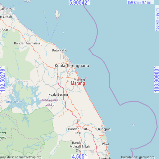
Marang GPS coordinates[2]
5° 12' 20.16" North, 103° 12' 21.24" East
| Map corner | latitude | longitude |
|---|---|---|
| Upper-left | 5.90542°, | 102.50278° |
| Center: | 5.2056°, | 103.2059° |
| Lower-right: | 4.505°, | 103.90903° |
| Map W x H: | 155.7×155.7 km | = 96.7×96.7mi |
| max Lat: | 6.88732° ⇑33.7% North |
| Marang: | 5.2056° |
| min Lat: | ⇓66.3% South 1.24722° |
| min Long | Marang | max Long |
| 99.68252° | 103.2059° | 118.61119° |
| W 70.8%⇐ | ⇒29.2% E |
Elevation
Elevation of Marang is 14 m = 46 ft, and this is 30.7 m = 101 ft below average elevation for this country.
| Max E: |
1488 m = 4882 ft | 49.4% |
| Avg. | 44.7 m = 147 ft | |
| Marang | 14 m = 46 ft | |
Min E: |
0 m = 0 ft | 50.6% |
See also: Malaysia elevation on elevation.city.
Geographical zone
Marang is located in North Torrid zone (between Equator and Tropic of Cancer). Distance of Equator is 578.8 km =359.6 mi to South.| Distance of | km | miles | from Marang |
|---|---|---|---|
| North Pole | 9428.3 | 5858.5 | to North |
| Arctic Circle | 6822.4 | 4239.2 | to North |
| Tropic Cancer | 2027.1 | 1259.6 | to North |
| Equator | 578.8 | 359.6 | to South |


Nearby cities:
15 places around Marang: (largest is in red/bold)
• Cukai
108.8 km =67.6 mi,  167°
167°
• Gua Musang
141.6 km =88 mi,  255°
255°
• Jertih
98.6 km =61.3 mi,  306°
306°
• Kampong Kadok
137.8 km =85.6 mi, 309°
• Kampong Pangkal Kalong
135 km =83.9 mi, 305°
• Kampung Kuala Besut
100.6 km =62.5 mi, 313°
• Kertih
81.4 km =50.6 mi,  160°
160°
• Ketereh
135 km =83.9 mi, 308°
• Kota Bharu
147.5 km =91.7 mi, 313°
• Kuala Besut
100.3 km =62.3 mi, 314°
• Kuala Terengganu
15.6 km =9.7 mi,  332°
332°
• Paka
68.2 km =42.4 mi, 157°
• Peringat
137.4 km =85.4 mi, 312°
• Pulai Chondong
130.8 km =81.3 mi,  304°
304°
• Tanah Merah
134.3 km =83.5 mi, 299°
Sources, notices
• [Note1] Compared only with cities in Malaysia existing in our database
• [Src1] Map data: © OpenStreetMap contributors (CC-BY-SA)
• [Src2] Other city data from geonames.org with taken over terms of usage.
• [Src3] Geographical zone / Annual Mean Temperature by Robert A. Rohde @ Wikipedia
