Kampung Kuala Besut geodata
Kampung Kuala Besut (Terengganu) is a populated place; located in Malaysia in Asia/Kuala_Lumpur (GMT+8) time zone. With population of 2,400 people, there are 166 cities with bigger population in this country. Compared to other cities in Malaysia, 81.5% of cities are located further ↓South; 64% of cities are located further ←West and 82% of cities have higher elevation than Kampung Kuala Besut. Note1


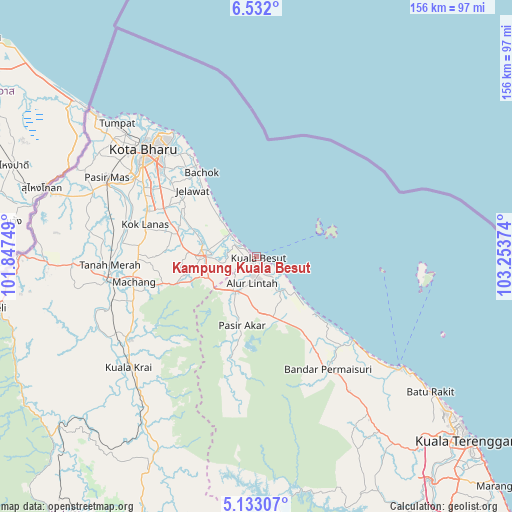
Kampung Kuala Besut GPS coordinates[2]
5° 49' 58.692" North, 102° 33' 2.196" East
| Map corner | latitude | longitude |
|---|---|---|
| Upper-left | 6.532°, | 101.84749° |
| Center: | 5.83297°, | 102.55061° |
| Lower-right: | 5.13307°, | 103.25374° |
| Map W x H: | 155.5×155.6 km | = 96.6×96.7mi |
| max Lat: | 6.88732° ⇑18.5% North |
| Kampung Kuala Besut: | 5.83297° |
| min Lat: | ⇓81.5% South 1.24722° |
| min Long | Kampung Kuala B | max Long |
| 99.68252° | 102.55061° | 118.61119° |
| W 64%⇐ | ⇒36% E |
Elevation
Elevation of Kampung Kuala Besut is 7 m = 23 ft, and this is 37.7 m = 124 ft below average elevation for this country.
| Max E: |
1488 m = 4882 ft | 82% |
| Avg. | 44.7 m = 147 ft | |
| Kampung Kuala Besut | 7 m = 23 ft | |
Min E: |
0 m = 0 ft | 18% |
See also: Malaysia elevation on elevation.city.
Geographical zone
Kampung Kuala Besut is located in North Torrid zone (between Equator and Tropic of Cancer). Distance of Equator is 648.6 km =403 mi to South.| Distance of | km | miles | from Kampung Kuala Besut |
|---|---|---|---|
| North Pole | 9358.5 | 5815.1 | to North |
| Arctic Circle | 6752.6 | 4195.9 | to North |
| Tropic Cancer | 1957.4 | 1216.3 | to North |
| Equator | 648.6 | 403 | to South |


Nearby cities:
15 places around Kampung Kuala Besut: (largest is in red/bold)
• Gua Musang
123.6 km =76.8 mi,  211°
211°
• Jertih
12.9 km =8 mi, 211°
• Kampong Kadok
38.1 km =23.7 mi,  299°
299°
• Kampong Pangkal Kalong
38.1 km =23.7 mi,  284°
284°
• Kampung Lemal
50.3 km =31.3 mi, 295°
• Ketereh
36.2 km =22.5 mi,  292°
292°
• Kota Bharu
46.9 km =29.1 mi,  313°
313°
• Kuala Besut
0.5 km =0.3 mi,  89°
89°
• Kuala Terengganu
86 km =53.4 mi,  130°
130°
• Marang
100.6 km =62.5 mi, 133°
• Pasir Mas
51.4 km =31.9 mi, 297°
• Peringat
37 km =23 mi, 307°
• Pulai Chondong
35.5 km =22.1 mi, 276°
• Tanah Merah
44.5 km =27.7 mi,  265°
265°
• Tumpat
58.4 km =36.3 mi, 314°
Sources, notices
• [Note1] Compared only with cities in Malaysia existing in our database
• [Src1] Map data: © OpenStreetMap contributors (CC-BY-SA)
• [Src2] Other city data from geonames.org with taken over terms of usage.
• [Src3] Geographical zone / Annual Mean Temperature by Robert A. Rohde @ Wikipedia
