Kampung Kok geodata
Kampung Kok (Kedah) is a populated place; located in Malaysia in Asia/Kuala_Lumpur (GMT+8) time zone. With population of 4,160 people, there are 162 cities with bigger population in this country. Compared to other cities in Malaysia, 96.6% of cities are located further ↓South; 100% of cities are located further →East and 94.4% of cities have higher elevation than Kampung Kok. Note1


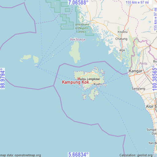
Kampung Kok GPS coordinates[2]
6° 22' 3.324" North, 99° 40' 57.072" East
| Map corner | latitude | longitude |
|---|---|---|
| Upper-left | 7.06588°, | 98.9794° |
| Center: | 6.36759°, | 99.68252° |
| Lower-right: | 5.66834°, | 100.38565° |
| Map W x H: | 155.4×155.4 km | = 96.6×96.6mi |
| max Lat: | 6.88732° ⇑3.4% North |
| Kampung Kok: | 6.36759° |
| min Lat: | ⇓96.6% South 1.24722° |
| min Long | Kampung Kok | max Long |
| 99.68252° | 99.68252° | 118.61119° |
| W 0%⇐ | ⇒100% E |
Elevation
Elevation of Kampung Kok is 5 m = 16 ft, and this is 39.7 m = 130 ft below average elevation for this country.
| Max E: |
1488 m = 4882 ft | 94.4% |
| Avg. | 44.7 m = 147 ft | |
| Kampung Kok | 5 m = 16 ft | |
Min E: |
0 m = 0 ft | 5.6% |
See also: Malaysia elevation on elevation.city.
Geographical zone
Kampung Kok is located in North Torrid zone (between Equator and Tropic of Cancer). Distance of Equator is 708 km =439.9 mi to South.| Distance of | km | miles | from Kampung Kok |
|---|---|---|---|
| North Pole | 9299.1 | 5778.2 | to North |
| Arctic Circle | 6693.2 | 4159 | to North |
| Tropic Cancer | 1897.9 | 1179.3 | to North |
| Equator | 708 | 439.9 | to South |


Nearby cities:
15 places around Kampung Kok: (largest is in red/bold)
• Alor Setar
79.8 km =49.6 mi,  110°
110°
• Ayer Hangat
16.5 km =10.3 mi,  69°
69°
• Bedong
115.8 km =72 mi,  127°
127°
• Gurun
106.8 km =66.4 mi,  124°
124°
• Jitra
82.4 km =51.2 mi,  97°
97°
• Kampung Bukit Hantu
11.1 km =6.9 mi,  92°
92°
• Kampung Kilim
19 km =11.8 mi,  77°
77°
• Kangar
57.6 km =35.8 mi, 81°
• Kuah
18.3 km =11.4 mi, 104°
• Kuala Kedah
74.5 km =46.3 mi, 113°
• Kuala Perlis
49.9 km =31 mi, 85°
• Kuala Teriang
3.6 km =2.2 mi, 96°
• Padang Mat Sirat
5.9 km =3.7 mi, 104°
• Pantai Cenang
9.6 km =6 mi,  148°
148°
• Tanjung Rhu
17.9 km =11.1 mi,  58°
58°
Sources, notices
• [Note1] Compared only with cities in Malaysia existing in our database
• [Src1] Map data: © OpenStreetMap contributors (CC-BY-SA)
• [Src2] Other city data from geonames.org with taken over terms of usage.
• [Src3] Geographical zone / Annual Mean Temperature by Robert A. Rohde @ Wikipedia
