Itu geodata
Itu (Akwa Ibom) is a seat of a second-order administrative division; located in Nigeria in Africa/Lagos (GMT+1) time zone. With population of 36,358 people, there are 158 cities with bigger population in this country. Compared to other cities in Nigeria, 92% of cities are located further ↑North; 63.5% of cities are located further ←West and 89.8% of cities have higher elevation than Itu. Note1


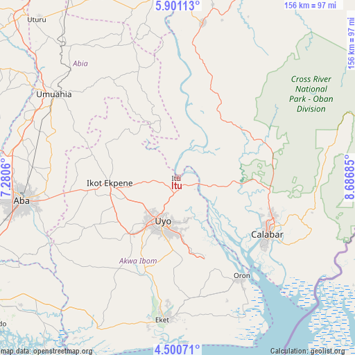
Itu GPS coordinates[2]
5° 12' 4.716" North, 7° 59' 1.428" East
| Map corner | latitude | longitude |
|---|---|---|
| Upper-left | 5.90113°, | 7.2806° |
| Center: | 5.20131°, | 7.98373° |
| Lower-right: | 4.50071°, | 8.68685° |
| Map W x H: | 155.7×155.7 km | = 96.7×96.7mi |
| max Lat: | 13.7543° ⇑92% North |
| Itu: | 5.20131° |
| min Lat: | ⇓8% South 4.31231° |
| min Long | Itu | max Long |
| 2.73333° | 7.98373° | 14.46552° |
| W 63.5%⇐ | ⇒36.5% E |
Elevation
Elevation of Itu is 32 m = 105 ft, and this is 264.5 m = 868 ft below average elevation for this country.
| Max E: |
1599 m = 5246 ft | 89.8% |
| Avg. | 296.5 m = 973 ft | |
| Itu | 32 m = 105 ft | |
Min E: |
2 m = 7 ft | 10.2% |
See also: Nigeria elevation on elevation.city.
Geographical zone
Itu is located in North Torrid zone (between Equator and Tropic of Cancer). Distance of Equator is 578.3 km =359.3 mi to South.| Distance of | km | miles | from Itu |
|---|---|---|---|
| North Pole | 9428.7 | 5858.7 | to North |
| Arctic Circle | 6822.8 | 4239.5 | to North |
| Tropic Cancer | 2027.6 | 1259.9 | to North |
| Equator | 578.3 | 359.3 | to South |


Nearby cities:
15 places around Itu: (largest is in red/bold)
• Abak
32.5 km =20.2 mi,  221°
221°
• Afaha Ikot Ebak
37.1 km =23.1 mi,  256°
256°
• Afaha Offiong
38.7 km =24 mi,  192°
192°
• Akankpa
24.3 km =15.1 mi,  110°
110°
• Arochukwu
22.4 km =13.9 mi,  339°
339°
• Ibiaku Ntok Okpo
32.5 km =20.2 mi,  291°
291°
• Idu
19.4 km =12.1 mi,  168°
168°
• Ikot Ekpene
29.9 km =18.6 mi,  265°
265°
• Nung Udoe
31.7 km =19.7 mi,  184°
184°
• Odoro Ikpe
31 km =19.3 mi,  304°
304°
• Odot
41.6 km =25.8 mi, 171°
• Odukpani
40 km =24.9 mi,  100°
100°
• Oko Ita
9.8 km =6.1 mi, 263°
• Okopedi
42.2 km =26.2 mi,  158°
158°
• Uyo
17.6 km =10.9 mi,  198°
198°
Sources, notices
• [Note1] Compared only with cities in Nigeria existing in our database
• [Src1] Map data: © OpenStreetMap contributors (CC-BY-SA)
• [Src2] Other city data from geonames.org with taken over terms of usage.
• [Src3] Geographical zone / Annual Mean Temperature by Robert A. Rohde @ Wikipedia
