Ikot Ekpene geodata
Ikot Ekpene (Akwa Ibom) is a seat of a second-order administrative division; located in Nigeria in Africa/Lagos (GMT+1) time zone. With population of 254,806 people, there are 34 cities with bigger population in this country. Compared to other cities in Nigeria, 92.3% of cities are located further ↑North; 58.2% of cities are located further ←West and 78.9% of cities have higher elevation than Ikot Ekpene. Note1


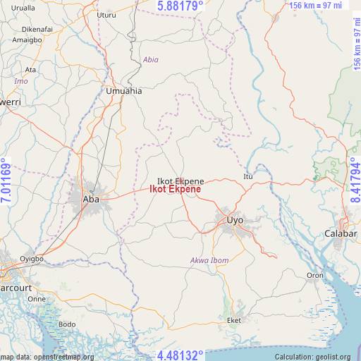
Ikot Ekpene GPS coordinates[2]
5° 10' 54.984" North, 7° 42' 53.316" East
| Map corner | latitude | longitude |
|---|---|---|
| Upper-left | 5.88179°, | 7.01169° |
| Center: | 5.18194°, | 7.71481° |
| Lower-right: | 4.48132°, | 8.41794° |
| Map W x H: | 155.7×155.7 km | = 96.7×96.7mi |
| max Lat: | 13.7543° ⇑92.3% North |
| Ikot Ekpene: | 5.18194° |
| min Lat: | ⇓7.7% South 4.31231° |
| min Long | Ikot Ekpene | max Long |
| 2.73333° | 7.71481° | 14.46552° |
| W 58.2%⇐ | ⇒41.8% E |
Elevation
Elevation of Ikot Ekpene is 89 m = 292 ft, and this is 207.5 m = 681 ft below average elevation for this country.
| Max E: |
1599 m = 5246 ft | 78.9% |
| Avg. | 296.5 m = 973 ft | |
| Ikot Ekpene | 89 m = 292 ft | |
Min E: |
2 m = 7 ft | 21.1% |
See also: Ikot Ekpene elevation on elevation.city.
Geographical zone
Ikot Ekpene is located in North Torrid zone (between Equator and Tropic of Cancer). Distance of Equator is 576.2 km =358 mi to South.| Distance of | km | miles | from Ikot Ekpene |
|---|---|---|---|
| North Pole | 9430.9 | 5860.1 | to North |
| Arctic Circle | 6825 | 4240.9 | to North |
| Tropic Cancer | 2029.7 | 1261.2 | to North |
| Equator | 576.2 | 358 | to South |


Nearby cities:
15 places around Ikot Ekpene: (largest is in red/bold)
• Abak
23.7 km =14.7 mi,  159°
159°
• Afaha Ikot Ebak
9 km =5.6 mi,  225°
225°
• Arochukwu
31.8 km =19.8 mi,  43°
43°
• Ibiaku Ntok Okpo
14.1 km =8.8 mi,  358°
358°
• Idu
37.5 km =23.3 mi,  116°
116°
• Ikot Akpa Nkuk
38.2 km =23.7 mi,  205°
205°
• Isiala Oboro
29.8 km =18.5 mi,  326°
326°
• Itu
29.9 km =18.6 mi,  85°
85°
• Nto Edino
17.5 km =10.9 mi,  298°
298°
• Odoro Ikpe
20 km =12.4 mi,  11°
11°
• Oko Ita
20 km =12.4 mi, 86°
• Omoba
34.8 km =21.6 mi,  281°
281°
• Urua Inyang
26.3 km =16.3 mi, 227°
• Utu Etim Ekpo
22.8 km =14.2 mi, 210°
• Uyo
28.2 km =17.5 mi, 120°
Sources, notices
• [Note1] Compared only with cities in Nigeria existing in our database
• [Src1] Map data: © OpenStreetMap contributors (CC-BY-SA)
• [Src2] Other city data from geonames.org with taken over terms of usage.
• [Src3] Geographical zone / Annual Mean Temperature by Robert A. Rohde @ Wikipedia
